Category:Earth Science from Space
New Space / Earth Sciences from Space
- Micro-Satellites
- When Doves Fly
- Planet API
- A "Thin Blue Layer"
- From the Vantage Point of Space
- New Definitions of National Security
Micro-Satellites, low-cost earth imaging

Geoscience -- #Geo360: Eyes in the Sky, Monitoring the Earth by Satellite
2015 Update
About Planet Labs Documentation Intro
February 5, 2015 - Private Spending on Space Is Headed for a New Record - Space Race 2.0 #NewSpace
Planet Labs has raised more than $160 million and launched 73 global imaging satellites. The growth was hard to imagine three years ago, when co-founder Will Marshall built the first of the miniature satellites nicknamed “doves” in a Silicon Valley garage.
“A lot of people were very skeptical, and what we were trying to do seemed ludicrous,” said Marshall, a former engineer at NASA Ames Research Center in Mountain View, California. “But we have assets in orbit, and customers who are very interested in the data. Every time we take a picture, we can see how the world is changing.” -- Bloomberg
Planet Labs, flying Doves unprecedented, observing Planet Earth with 'rapid cadence' imaging opening possibilities never before offered
○ ○ ○ ○
2014
Building an API for the Planet: Will Marshall/PlanetLabs [1]
Mission: Democratising Access to Information About the Changing Planet
Time for Planet Labs 'Doves' to fly
Planet Labs "flock" / New Scientist [2] Flock 1
NanoRacks deployment into space [3] [4][5] [6]
○ ○ ○ ○
Earth Imaging -- Micro-satellites [7]
Nextgen #earthscience in era of #climatechange and #globalsecurity threat
“Five years from now, there might be 200 or more up there..." [10]
Geoscience Satellites -- Start-up companies
BlackBridge [11], Dauria [12], DigitalGlobe [13] [14] [15] GeoEye [16],
Firefly Space Systems [17] [18], GeoOptics [19], NanoRacks [20], [21] [22]
NovaWurks [23], OmniEarth [24] [25] [26] [27], OrbitLogic [28], PlanetiQ [29]
Planet Labs [30] Pulse [31] [32] [33], RapidEye [34], Skybox [35] [36] [37]
Teledyne [38], Tyvak Nano-Sat [39], Urthecast [40]

OpenNEX, NASA asks public to join in with space data monitoring earth [41]
○ ○ ○ ○
On the launch of Planet Labs 'Dove' nanosatellites -- applications yet-to-be developed #OpenData #PlanetCitizens
Robbie Schingler, co-founder of Planet Labs: “We are motivated to make information about the changing planet available to all people, especially the people who need it the most..."
"The imagery could be used by anyone who cares about changes in land use over time.” [42]
"Rapid cadence imagery, like Planet Labs is developing, helps us become better, more sustainable stewards of Earth." [43]
Will Marshall, co-founder of Planet Labs talks of democratization of space: videos [44] [45]
Planet Labs largest fleet of Earth-imaging satellites.
The data is expansive and of added value over time:
- - humanitarian applications, earth resource monitoring, sustainability and eco-nomics
- - extreme event and disaster relief
- - food systems, water distribution, improving agriculture
- - business intelligence (BI) metrics/performance
- - research, science
○ ○ ○ ○
June 2014 Google Buys Skybox
[46]
[47]
[48]
[49]
[Background] June 18, 2013 Inside a Startup’s Plan to Turn a Swarm of DIY Satellites Into an All-Seeing Eye [50]
June 16, 2014 - Wall Street Journal / by Christopher Mims [51]
By 2016 or so, Skybox will be able to take full images of the Earth twice a day, at a resolution that until last week was illegal to sell commercially — all with just a half-dozen satellites.
By the time its entire fleet of 24 satellites has launched in 2018, Skybox will be imaging the entire Earth at a resolution sufficient to capture, for example, real-time video of cars driving down the highway. And it will be doing it three times a day.
You might think, thanks to weather maps and the satellite view on Google Maps, that such imagery already is readily available. But because satellites were, until recently, so expensive to build and launch, that isn't the case. There are only nine satellites in orbit now that capture high resolution images for the commercial market, and their capabilities are regularly commandeered for national-security purposes by the U.S. government. That means most of the pictures of the Earth that you've seen are of poor quality and years out of date.
At Google, the business of Skybox isn't data, but knowledge. "We think we are going to fundamentally change humanity's understanding of the economic landscape on a daily basis," says Skybox co-founder Dan Berkenstock...
Skybox's images will inevitably lead to apps and services no one can envision — with unknowable disruptive potential. Skybox executives tell me they hope to offer their data to outside developers... In the short term, Google has said it would use Skybox's images to improve the search company's maps.
A patent revealed in May indicates that Google builds its superaccurate maps directly from satellite imagery, and the company has long had a deal with Skybox competitor DigitalGlobe, whose satellites cost 10 times as much as Skybox's and are 10 times heavier, leading to much higher launch costs. DigitalGlobe's stock dipped 4% on news of the Skybox deal...
○ ○ ○ ○
May 2014 Skybox and Planet Labs / re Google's purchase of Skybox, Google has a business division called “Earth Enterprise” that provides mapping data for large organizations, institutions and businesses. “Google Earth Enterprise allows you to store and process terabytes of imagery, terrain and vector data on your own server infrastructure, and publish maps securely for your users to view using Google Earth desktop or mobile apps, or through your own application using the Google Maps API..." [52]
Feb 2014 Planet Labs versus Skybox / The next step is something more like a Google for Earth: a search engine where people can find satellite photos taken in real or near-real time that answer questions like “How many ships are in the Port of Houston today?” or “How much corn is currently growing in Iowa?” [53]
_ _ _ _ _ _ _ _ _ _ _ _ _ _ _ _ _ _ _ _ _ _ _ _ _ _ _ _ _ _ _ _ _ _ _ _ _ _ _ _ _ _ _ _ _ _ _ _ _ _ _ _ _ _ _ _ _ _ _ _ _ _ _
“With all these start-ups, the things you’ll be able to do with satellite images will grow exponentially..." IEEE, May 2014
_ _ _ _ _ _ _ _ _ _ _ _ _ _ _ _ _ _ _ _ _ _ _ _ _ _ _ _ _ _ _ _ _ _ _ _ _ _ _ _ _ _ _ _ _ _ _ _ _ _ _ _ _ _ _ _ _ _ _ _ _ _ _
June 2014
- U.S. Department of Commerce lifts ban on satellite images showing features smaller than 20 inches - DigitalGlobe [54] [55] [56] [57]
- "Companies had not been allowed to make use of images where features smaller than 50cm were visible"
- Satellites Are Cleared to Take Photos at Mailbox-Level Detail per DigitalGlobe petition
- Worldview-3 satellite is set to launch in August. Digital Globe [58] [59] says it will now be able to sell images that show features as small as 31cm [60]
- Sites like Google and Bing Maps will be able to use higher-quality satellite images in near real-time [61] [62]... eventually real-time
GP360: Earth-monitoring, data-sharing, open source, is in the wings...
Citizen-networking/schools-education space-earth projects -- education looks at #earthscience from space... [63] [64]
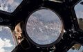
24/7 high-definition video of Earth <Urthecast-ISS> [65] Urthecast APIs
Live from the International Space Station [66] [67] [68] [69]
Earth sciences/NASA-JPL and gov contractors 'Eyes on the Earth'

Feb 2014
Until recently, since the launch of the original Landsat program in 1972, generating images of Earth from space has been the near-exclusive domain of enormous, multi-million dollar satellites sponsored by nations and major defense corporations.
- New micro-satellites, including those launched from the ISS, aim to make real-time imaging available for a fraction of the past decades price and move us from military-defense-communication operations to economic/entrepreneurial functions, 'earth systems-monitoring' and biosphere sustainability, space 'tourism' and low earth orbit travel...
______________________
Earth systems-monitoring - http://www.earthzine.org/geo-and-geoss-the-group-on-earth-observations-and-the-global-earth-observations-system-of-systems/
<more> http://gizmodo.com/meet-the-flockers-iss-launches-low-cost-earth-imaging-1517232660
Earth Imaging - background – 2007 - Acquiring large data sets of Earth imagery in a simple, low-cost way, represents a new market opportunity beginning to be addressed. New telescope designs enable low-cost satellites with that purpose. [70]

Jan 2014 - "Flocking" "Doves" "Nanosatellites" - http://www.scientificamerican.com/article/flock-of-nano-satellites-to-capture-high-res-views-of-whole-earth/
Google goes mapping - http://gizmodo.com/how-swarms-of-tiny-satellites-are-creating-a-real-time-1497890594
Swarms of small satellites set to deliver close to real-time imagery - http://www.nature.com/news/many-eyes-on-earth-1.14475

Dec 2013
"How Planet Labs Is Saving the Earth with 'Homemade' Satellites. It took less than six months to build twenty-eight of them"...
<more> http://www.businessinsider.com/planet-labs-fleet-of-homemade-satellites-2013-12?op=1
http://www.space.com/23739-tiny-earth-satellite-fleet-launching-december.html
Nov 2013
Flock of Mini- and Micro-sats delivered to space with international Dnepr co-venture - http://www.space.com/23738-dnepr-rocket-launches-32-satellites.html
'Minotaur 1 delivers 29 mini's/CubeSats including first-ever design/build satellite project of a US high school'
http://www.orbital.com/NewsInfo/MissionUpdates/MinotaurI_ORS-3/
○ ○ ○ ○
CubeSats - CubeSat specifications accomplish several high-level goals. Simplification of the satellite's infrastructure makes it possible to design and produce workable satellites at low cost.... Encapsulation of the launcher–payload interface takes away the prohibitive amount of managerial work... Unification among payloads and launchers enables quick exchanges of payloads and utilization of launch opportunities...
CubeSat 'nano-satellites' aim to adhere to the standards described in the CubeSat design specification -- CubeSats initiatives were conceived from educational institutions... In 2004, with their relatively small size, first-gen CubeSats could each be made and launched to Low-Earth Orbit (LEO) for an estimated $65,000–$80,000. Acc to Wikipedia, 'recent' launch prices have been $100,000-$125,000, plus approximately $10,000 to construct a CubeSat. This price tag, far lower than most satellite launches, has made CubeSat a viable option for schools and universities across the world.
- LightSail with CubeSats, Planetary Society - Launch date April 2016 [71] Video/July 2014 Explore Planets/TW
Sept 2013
Sensors and Systems - “Every year the technology improves, with better computers and storage and payloads. The technological evolution improves, price points continue to come down, and now with a small 150 to 300 kg spacecraft for $10 to $20 million you can do what you were doing with a 1,000 kg spacecraft five to 10 years ago for $500 million.” Surrey Satellite Technology-RapidEye satellite imagery “Changing the Economics of Space” ... co-ventures/joint ventures/'ride-alongs'/shared platforms/accessible data
<more> http://www.sstl.co.uk/ - note connection to SpaceX - Elon Musk - note Elon Muck opening up the Tesla platform on June 12, 2014 - http://en.wikipedia.org/wiki/Surrey_Satellite_Technology - http://www.teslamotors.com/blog/all-our-patent-are-belong-you
June 2013
Citizens in Space - http://www.citizensinspace.org/2013/06/planet-labs-to-launch-flock-1/
Opening up to understanding and interacting with our eco-operating systems
Share-able earth science data enabling earth biosphere systems monitoring/preservation policy advocacy by #globalcitizen orgs
_ _ _ _ _ _ _ _ _ _ _ _ _ _ _ _ _ _ _ _ _
Earth systems, monitoring over time - http://www.earthzine.org/geo-and-geoss-the-group-on-earth-observations-and-the-global-earth-observations-system-of-systems/
GEO - Group on Earth Observations - http://www.earthobservations.org/about_geo.shtml
- GEOSS - Global Earth Observation System of Systems - http://www.earthobservations.org/geoss.shtml
_ _ _ _ _ _ _ _ _ _ _ _ _ _ _ _ _ _ _ _ _ _ _ _ _ _ _ _ _ _ _ _ _ _ _ _ _ _ _ _ _

Subcategories
This category has the following 20 subcategories, out of 20 total.
A
C
D
E
G
N
O
P
S
T
W
Pages in category "Earth Science from Space"
The following 88 pages are in this category, out of 88 total.
C
- Carbon Brief
- Clearcutting
- Climate Change - Global Warming Keyword-Terms
- Climate Change Denier Talking Points -- and Rebuttals
- Climate Conference - Paris 2015
- Climate Desk
- Climate Law Blog @Columbia Law School
- Climate migration
- Climate News
- Climate News Events Archive ... 1970 to Today
- Climate Plans Enforcement - Resources
E
- Each of us can make a positive difference
- Earth
- Earth from NASA
- Earth Imaging-New Space
- Earth Right Now
- Earth Science Eco-Fields
- Earth Science Research from Space
- Earth Science Vital Signs
- EarthPOV
- EarthTime
- Earthviews
- Earthviews from Astronauts
- Environmental full-cost accounting
- Environmental Rules Rolled Back
- Environmental Security Organizations
- ESA Living Planet Announcement - May 2022
- Ethics and Climate Change
- European Union Green Deal - Fit for 55
- ExxonMobil and US House Science Committee v US Attorneys General and Environmental Groups
G
- GEOID
- George E. Brown Jr
- Glasgow Climate Summit - Pledges, Promises, Declarations - What's Next Up
- Global Climate Action Summit
- Global Fishing Watch
- Global Forest Watch
- Google Earth
- Google Earth Timelapse
- Green Politics 360
- Green Politics with GreenPolicy360
- Greening Our Blue Planet
- GreenPolicy360 Archive Highlights 2021
- GreenPolicy360 Archive Highlights 2022
I
L
P
S
Media in category "Earth Science from Space"
The following 11 files are in this category, out of 875 total.
(previous page) (next page)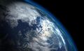 'Thin Blue Layer' of Earth's Atmosphere 2.jpg 800 × 486; 46 KB
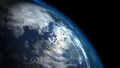 'Thin Blue Layer' of Earth's Atmosphere l.jpg 853 × 486; 46 KB
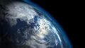 'Thin Blue Layer' of Earth's Atmosphere xl.jpg 1,152 × 648; 79 KB
 -HelloEarth.png 579 × 381; 0 bytes
 03-Scott-Kelly-NASA.jpg 800 × 500; 113 KB
 1977 from the Office of Science and Technology Policy.jpg 661 × 711; 177 KB
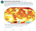
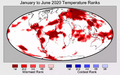 2020 record temperatures.png 800 × 502; 358 KB
 3-15-2016 10-49-38 AM.png 702 × 862; 396 KB
 3-15-2016 12-29-07 PM.png 538 × 701; 201 KB
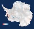 5 19 14 andrew antarcticaelevationchanges-640x547.jpg 640 × 547; 59 KB
 7-20-2020 GreenPolicy360 RT No.2.jpg 591 × 510; 125 KB


![[3]](http://www.greenpolicy360.net/mw/images/Doves_launched_from_ISS_float_against_Earth_horizon_m.jpg)
![[31]](http://www.greenpolicy360.net/mw/images/Doves_close-up-of-cubesats-leaving-nanoracks-deployer-2014-02-11_m.jpg)
- Earth Imaging
- Earth Observations
- Earth Science
- Environmental Security
- Environmental Security, National Security
- Global Security
- National Security
- New Space
- Planet API
- Planet Citizen
- Planet Scientist
- Atmospheric Science
- Biogeosciences
- Climate Change
- Cryosphere
- Geophysics and Geochemistry
- Mineralogy
- Geology
- Geophysics
- Hydrology
- Natural Resources
- Ocean Science
- Planetary Science
- Space Science and Space Physics