Category:Aquifers
<addthis />
- Excessive groundwater pumping is ... unsustainable 🔵 Aquifer groundwater must be protected! 🔵 How is *your aquifer* doing?
As Groundwater Levels Fall in the U.S., Powerful Players Block Change
The aquifer is running out of water, fast. But the (water control) board hasn’t slowed down the pumping.
In a country where the value of land often depends on access to water, powerful interests in agriculture, heavy industry and real estate draw vast amounts of water out of the ground. For generations, that water has been treated as an unlimited resource in much of the United States, freely available to anyone who owns a piece of land and can drill a well. Entire local economies have been built around the assumption that the water will never run out.
Now it is starting to run out...
America Is Using Up Its Groundwater Like There’s No Tomorrow
Unchecked overuse is draining and damaging aquifers nationwide, a data investigation by the New York Times revealed, threatening millions of people and America’s status as a food superpower
The US Midwest Aquifer and Underground the Aquifer Water Supplies Throughout the World Are Now in Danger
National Geographic / What happens to the US Midwest as the Ogallala is drained'
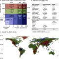
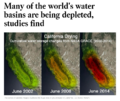
The world’s largest underground aquifers – a source of fresh water for hundreds of millions of people — are being depleted at alarming rates, according to new NASA satellite data that provides the most detailed picture yet of vital water reserves hidden under the Earth’s surface.
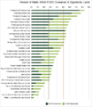
Twenty-one of the world’s 37 largest aquifers — in locations from India and China to the United States and France — have passed their sustainability tipping points, meaning more water was removed than replaced during the decade-long study period, researchers announced Tuesday. Thirteen aquifers declined at rates that put them into the most troubled category. The researchers said this indicated a long-term problem that’s likely to worsen as reliance on aquifers grows.
Scientists had long suspected that humans were taxing the world’s underground water supply, but the NASA data was the first detailed assessment to demonstrate that major aquifers were indeed struggling to keep pace with demands...
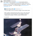
Earth Science Research from Space
"Monitoring the world's groundwater with the GRACE" satellite mission / NASA Report / June 2015
🌎
🌎
Subcategories
This category has the following 9 subcategories, out of 9 total.
Pages in category "Aquifers"
The following 30 pages are in this category, out of 30 total.
G
Media in category "Aquifers"
The following 144 files are in this category, out of 144 total.
- 3-15-2016 12-29-07 PM.png 538 × 701; 201 KB
- 3M lawsuit re forever chemicals - June 2023.png 603 × 600; 357 KB
- AB 2480 Meadows and Forest Water Infrastructure.png 481 × 375; 248 KB
- About website of The Invading Sea.png 800 × 343; 126 KB
- Against the Tide - Cover - by Cornelia Dean.jpg 308 × 475; 57 KB
- Agriculture and seeds.jpg 1,920 × 1,080; 1.16 MB
- Aldis zone blog.jpg 500 × 498; 67 KB
- AOC March 26, 2019.jpg 597 × 433; 58 KB
- Aquifers earthsciencefromspace Grace CA3.png 772 × 652; 559 KB
- Aquifers global earth observations by grace20150616-16 m.jpg 800 × 450; 117 KB
- Aquifers global earth observations by grace20150616-16.jpg 1,600 × 900; 317 KB
- Aquifers globalstudy 2015.png 668 × 451; 299 KB
- Aquifers June2015 past the tipping point.png 533 × 615; 195 KB
- Arable land percent world.png 1,357 × 628; 40 KB
- Barrier island hubris 6-29-2021.jpg 490 × 635; 111 KB
- Biggest climate related legislation in history - 1.png 800 × 188; 68 KB
- Bill Mollison 1928-2016.pdf ; 99 KB
- Bill Mollison courtesy of Permaculture magazine.jpg 460 × 300; 0 bytes
- Bill Mollison the day after his passing memories.png 1,381 × 651; 1.65 MB
- California's Central Valley Earth View June 2015.png 1,571 × 767; 0 bytes
- Caroline Lucas-Green New Deal.jpg 584 × 391; 71 KB
- Celebrating 50 Years of Landsat.png 600 × 610; 909 KB
- Challenge of Acting for the Commons.png 700 × 548; 175 KB
- Cisterns rebateprogram.jpg 628 × 390; 355 KB
- CO2 higher than in the past 5 million yrs.jpg 514 × 285; 62 KB
- Common Ground, the Movie.png 600 × 756; 775 KB
- Commons-concepts permanent culture now s.png 448 × 211; 75 KB
- Commons-concepts permanent culture now.png 830 × 391; 39 KB
- Desertification map.png 1,280 × 828; 588 KB
- Diane Walder in Miami Beach.jpg 775 × 787; 147 KB
- Disaster scenarios raise the stakes for Colorado River - 1.png 640 × 213; 56 KB
- Disaster scenarios raise the stakes for Colorado River - 2.png 640 × 154; 14 KB
- DJT - US message to world.jpg 800 × 266; 45 KB
- Dove1 image.jpg 420 × 308; 26 KB
- Dr Volts talks of lawns and their problems.jpg 492 × 376; 49 KB
- Drought Monitor Map - April 2022.png 800 × 459; 238 KB
- Earth mapped.png 800 × 783; 254 KB
- Earths-Future .jpg 351 × 198; 41 KB
- Earths-Future-cover.jpg 251 × 325; 48 KB
- Ecostress Mission-Aug 2020.jpg 640 × 311; 85 KB
- EPA and the Green Bank - Feb 2023.png 476 × 542; 244 KB
- Estates at Acqualina - Sunny Isles Miami.jpg 746 × 600; 117 KB
- FaceApp Florida.jpg 640 × 428; 40 KB
- Flooding in South Florida.png 640 × 742; 293 KB
- Florida and climate change denial.png 640 × 192; 46 KB
- Florida via NASA 2022.png 800 × 1,020; 1.12 MB
- Florida Wildlife Corridor - 2022 illustration.png 800 × 628; 473 KB
- Florida Wildlife Corridor FLWC Water Benefits December 2022.png 768 × 886; 109 KB
- FOOD.jpg 983 × 311; 117 KB
- Global Green New Deal.jpg 427 × 640; 32 KB
- Google Earth Hello2.png 800 × 375; 863 KB
- Green New Deal - Bloomberg Jan 29,2019.png 640 × 757; 589 KB
- Green New Deal - Resolution.pdf ; 55 KB
- Green New Deal - Strategic Demands - Oct 1, 2021.png 602 × 658; 245 KB
- Green Rain Barrels.jpg 576 × 768; 95 KB
- Green-New-Deal-December-2018-1.png 800 × 634; 207 KB
- Greenland ice sheet set to raise sea level significantly.png 640 × 340; 223 KB
- Groundwaterstudy 1.png 800 × 384; 237 KB
- Harvest the Rain cover .png 582 × 800; 1.06 MB
- Harvest the Rain reviews.png 800 × 879; 306 KB
- Hurricanes - Typhoons via NASA data.png 764 × 924; 1,022 KB
- Invading Seas warning 2024.png 757 × 587; 669 KB
- Kenny Ausubel quote.jpeg 415 × 163; 46 KB
- Land Remote Sensing Policy Act of 1992.jpg 563 × 480; 144 KB
- Landsat 50th anniv Sept 2016.jpg 800 × 456; 94 KB
- Landsat at 50.png 800 × 713; 345 KB
- Landsat band imagery2.png 800 × 400; 907 KB
- Landsat data site.png 657 × 600; 499 KB
- Landsat launched 50 years ago today.png 528 × 779; 755 KB
- Landsat NASA - Feb 11 2023.png 763 × 600; 578 KB
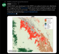
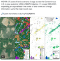
- Landsat US collection of maps 1985-2021.png 768 × 775; 1,018 KB
- Landsat, a 50 year legacy.png 528 × 575; 288 KB
- Lawn1.jpg 1,024 × 431; 135 KB
- Living Diversity or Not in Your Home Yard.png 436 × 640; 582 KB
- LivingEarth2.png 800 × 503; 478 KB
- Manchin again - July 15 2022.png 600 × 654; 523 KB
- Mangroves and Coastal Wetlands tracked by Landsat.png 600 × 716; 245 KB
- Mangroves regulate flooding - EDF.png 568 × 473; 328 KB
- Map of the World wiki commons m.png 679 × 314; 18 KB
- Map of the World wiki commons s.png 339 × 157; 13 KB
- Map of the World wiki commons.png 1,357 × 628; 19 KB
- Mar a lagoon tba.jpg 540 × 405; 40 KB
- Maya Lin Ghost Forest 5-17-2021.jpg 618 × 454; 123 KB
- Miami region sea level rise.gif 618 × 318; 191 KB
- Miami Reminder.jpg 411 × 292; 52 KB
- Miami sea level rise conf-May2018.jpg 800 × 600; 53 KB
- Move along Florida-May 2018.png 448 × 454; 342 KB
- Moving to Higher Ground.png 568 × 473; 307 KB
- NationalGeographic SouthPole melt West Antarctica 2016.jpg 630 × 438; 89 KB
- New Economics Foundation logo.png 476 × 123; 9 KB
- Not to worry 2016.png 539 × 401; 347 KB
- Permaculture-observation tip.jpg 480 × 540; 86 KB
- Planet and plan for an Earthdata platform.png 600 × 600; 280 KB
- Planet m.png 533 × 222; 155 KB
- Rain Garden Design courtesy of www.PermaDesign.com Nate Downey.png 800 × 614; 601 KB
- RainBarrels UNM.jpg 450 × 224; 53 KB
- Rising Seas, refugees, Phys.org Land Use July 2017.png 488 × 385; 190 KB
- River basins - watersheds.jpg 800 × 214; 111 KB
- SCOTUS decision on water protection.png 535 × 424; 299 KB
- Sea levels surge along southern US coast.png 640 × 441; 69 KB
- Sea Wall of Miami +++.jpg 526 × 220; 48 KB
- Sea-Level Rise Twice as High as Previously Predicted.png 701 × 225; 92 KB
- Seeds of Change, published 1994.png 628 × 763; 915 KB
- Seeds of Change.jpg 260 × 346; 27 KB
- Shrinking Shores Florida.png 750 × 336; 328 KB
- Soil is the root stuff.jpg 483 × 960; 97 KB
- South Florida Floodwaters.png 640 × 449; 251 KB
- Space stations - July 26 2022.png 544 × 462; 270 KB
- Surprise climate deal.png 589 × 735; 83 KB
- Tampa Bay Times Environment Hub - April 2025.jpg 769 × 768; 184 KB
- Threat Environment - TBay Times Series on Climate Change Impacts.png 556 × 864; 166 KB
- Timelapse.png 800 × 566; 676 KB
- Toby Hemenway-RIP Dec2016.png 503 × 327; 32 KB
- Tropical Cyclone - Hurricane Population Displacement Risks.jpg 800 × 385; 56 KB
- UN Mapping the World.png 740 × 477; 584 KB
- Unified sea level rise - Southeast Florida.jpg 800 × 418; 70 KB
- US River basins - watersheds.jpg 800 × 477; 131 KB
- USGS Groundwater depletion map 2013.png 794 × 490; 238 KB
- Venice flooding.png 530 × 516; 109 KB
- Virtual Earth cover.png 800 × 479; 833 KB
- Water Action News - March 2023.png 640 × 277; 103 KB
- Water Risk Projects.jpg 1,140 × 518; 124 KB
- Water shortage 4B people sci report-2016.png 853 × 233; 148 KB
- Water stress by country.png 2,159 × 1,115; 584 KB
- Water stress index map maplecroft.jpg 518 × 303; 123 KB
- WaterAction - 2023.PNG 480 × 640; 300 KB
- Watershed monitoring earthscience m.png 572 × 360; 143 KB
- World Map - Mercator projection v Google maps.jpg 800 × 545; 101 KB
- Youth vote estimates 2016 primary.png 800 × 490; 257 KB


