Global Fishing Watch
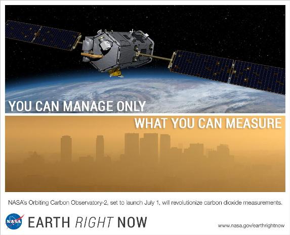
Satellites to Measure, Monitor & Manage
2024
Global Fishing Watch, from its beginnings with involvement with friends of GreenPolicy360, has been tracked here as chronicled below...
Check it out ... from the original idea, development, thru launch of the Global Fishing Watch system (and similar Global Forest Watch). The latest 'Sentinel' update brings another round of significant improvements and progress.
Tech Crunch reports:
Satellite imagery and machine learning offer a new, far more detailed look at the maritime industry, specifically the number and activities of fishing and transport ships at sea. Turns out there are way more of them than publicly available data would suggest, a fact that policymakers should heed. ...
(The former) understanding of the scale of the global fishing industry is all wrong. And if we don’t have good information to base our policies and science on, both will end up fundamentally flawed. ...
(Now, with this Global Fishing Watch upgrade) we are processing new radar imagery from the Sentinel-1 satellite as it is collected and identifying activity across the globe. This data can be seen and accessed on globalfishingwatch.org, and is current up to three days ago.”
Next up, with these 'game changing tools', is planet citizen action in countries and international organizations in order to put into place additional environmental laws and enforcement mechanisms to preserve and protect life in the oceans for today's generation and future generations.
Go, we go #PlanetCitizens.
Measure & Monitor to Manage...
- https://www.greenpolicy360.net/w/Virtual_Earth
- https://www.greenpolicy360.net/w/Earth_Science_Research_from_Space
- https://www.greenpolicy360.net/w/Planet_API
- https://www.greenpolicy360.net/w/Democratization_of_Space
- https://www.greenpolicy360.net/w/Category:Environmental_Laws
- https://www.greenpolicy360.net/w/Planet_Citizen_Action
- https://www.greenpolicy360.net/w/Earth_Imaging-New_Space
- https://www.greenpolicy360.net/w/The_Commons
- http://www.planetcitizens.org
2023
How disappearing ships could hold the clue to stopping illegal fishing
Via the Washington Post
Re: Identifying, tracking, and stopping illegal and pirate fishing ships
A team of data scientists and machine learning engineers called Global Fishing Watch collects data from fishing boats’ Automatic Identification System (AIS) transponders, whose signals are picked up by satellites and land-based receivers. Recently, the team at Global Fishing Watch had a novel idea: instead of looking for where fishing boats broadcast their positions, what if they looked for where they hid them? “The AIS data tells us a lot, but the absence of it does as well,” said Tyler Clavelle, a data scientist at Global Fishing Watch.
Together with scientists from the University of California at Santa Cruz and NOAA Fisheries, Global Fishing Watch analyzed more than 28 billion AIS signals from 2017 to 2019. The researchers identified more than 55,000 gaps in the data and discovered that disabled transponders hide about 6 percent of the globe’s commercial fishing activity.
○
November 2014
About the Global Fishing Watch / Project Launch
With the leadership of Google Earth Outreach and Rebecca Moore
Observing the world's fishing fleet, real time and over time
Game-changing Technology
Automatic identification systems, AIS signals, carry information about fishing vessels, e.g., name, country of origin, speed and position.
Today, except for illegals and pirates, the sector has reached a point where there is a comprehensive picture of where vessels are and where they’ve been, at any given time, encapsulated in billions of individual AIS signals.
At the same time, advances in machine learning and artificial intelligence are making it possible to see patterns in this glut of data.
A collaboration between environmental watchdog SkyTruth, Global Fishing Watch and Google, has been instrumental in laying the groundwork for AIS data analysis. The group has created algorithms that can be applied to large amounts of data to show the type of fishing activity, location or travel path of vessels, and made some of this data accessible in the form of an interactive map...
This complex supply chain can be documented and recorded electronically at sea and in port.
This type of measuring and monitoring work can bring reform to the fishing industry and help curb over fishing, resource depletion, and fraud, which is prevalent with seafood everywhere in the world.
High seas ocean fishery resources do not belong to a single nation, but rather are viewed as an international commons, a vital resource that is to be shared.
Knowing more about global fishing patterns can help inform policymakers and consumers... research is just getting started in this field.
“AIS tracking is going to increase and become more elaborate.”
- Time to Act for Sustainability: Oceans 360°
Sustainable Fishing Policies Are Possible
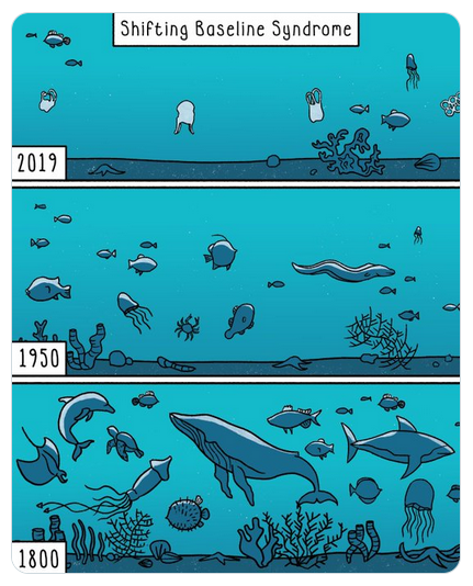
"Shifting Baselines"
From the Global Fishing Watch Project Announcement:
Global Fishing Watch is the product of a technology partnership between SkyTruth, Oceana, and Google Earth Outreach that is designed to show all of the trackable fishing activity in the ocean.
This interactive web tool – currently in prototype stage – is being built to enable anyone to visualize the global fishing fleet in space and time. Global Fishing Watch will reveal the intensity of fishing effort around the world, one of the stressors contributing to the precipitous decline of our fisheries.
With hundreds of millions of people around the world depending on our ocean for their livelihoods, and many more relying on the ocean for food, ensuring the long-term sustainability of our ocean is a critical global priority. We need a tool that harnesses the power of citizen engagement to hold our leaders accountable for maintaining an abundant ocean.
Global Fishing Watch will be available to the public, enabling anyone with an internet connection to monitor when and where commercial fishing is happening around the globe.
Citizens can use the tool to see for themselves whether their fisheries are being effectively managed. Seafood suppliers can keep tabs on the boats they buy fish from. Media and the public can act as watchdogs to improve the sustainable management of global fisheries. Fisherman can show that they are obeying the law and doing their part. Researchers will have access to a multi-year record of all trackable fishing activity.
The tool uses a global feed of vessel locations extracted from Automatic Identification System (AIS) tracking data collected by satellite, revealing the movement of vessels over time. The system automatically classifies the observed patterns of movement as either “fishing” or “non-fishing” activity.
This version of the Global Fishing Watch started with 3.7 billion data points, more than a terabyte of data from two years of satellite collection, covering the movements of 111,374 vessels during 2012 and 2013. We ran a behavioral classification model that we developed across this data set to identify when and where fishing behavior occurred. The prototype visualization contains 300 million AIS data points covering over 25,000 unique vessels. For the initial fishing activity map, the data is limited to 35 million detections from 3,125 vessels that we were able to independently verify were fishing vessels. Global Fishing Watch then displays fishing effort in terms of the number of hours each vessel spent engaged in fishing behavior, and puts it all on a map that anyone with a web browser will be able to explore.
- ○ ○ ○ ○ ○ ○
- "You want to change the world? We want to help..."
- ○ ○ ○ ○ ○ ○ ○ ○ ○ ○ ○ ○
- Biodiversity
- Bioneers
- Bioregionalism
- Citizen Science
- Climate Change
- Democratization of Space
- Earth360
- Earth Imaging
- Earth Observations
- Earth Science from Space
- Ecology Studies
- Fisheries
- Maps
- NASA
- New Space
- Oceans
- Ocean Science
- Planet Citizen
- Planet Citizens
- Planet Citizens, Planet Scientists
- Planet Scientist
- Resilience
- Sustainability
- Sustainability Policies


