Category:Maps
<addthis />

Earth Mapping
- Planet Citizens Mapping Planet Earth
- https://www.greenpolicy360.net/w/Virtual_Earth
- https://www.greenpolicy360.net/w/Planet_Citizens,_Planet_Scientists

····················································································
Digital maps are making quantum leaps in quality and utility ...
Type NAVD into Google
NOAA provides a baseline reference tool, 'Datums and Reference Frames', Monitor sea-level change with dynamic mapping.
A geodetic datum or reference frame is an abstract coordinate system with a reference surface (such as sea level) that serves to provide known locations to begin surveys and create maps.
NOAA and NASA Begin Sea Level Rise Project
🌎
How Facebook, Apple and Microsoft are contributing to an openly licensed map of the world
Collaborating in the open to build an openly licensed map of the world: OpenStreetMap
OpenStreetMap has grown into one of the most successful collaboratively maintained open datasets in the world. Today, contributors to the maps include not just local mappers, but also a diverse mix of commercial organisations, non-governmental organisations, humanitarian organisations and also large commercial organisations.
The Microsoft Open Maps team has recently released open data on building footprints in the US. Microsoft was among the first to release satellite imagery for use by OpenStreetMap and the images are now integrated into the default editor. It also has a community of mappers directly contributing to OpenStreetMap in Australia.
Apple has an internal volunteer programme that has around 5,000 staff contributing to Missing Maps, they’ve released building data for France and Denmark, and are engaged with data improvement projects around the world.
Facebook is exploring how artificial intelligence-assisted tracing can help to improve the quality of OpenStreetMap data in Thailand.
DigitalGlobe has made its satellite imagery available under a licence that will allow it to be used by the OpenStreetMap community to improve their mapping efforts.
Telenav launched OpenStreetCam to help collect openly-licensed street imagery and has now released open data and code to explore how machine learning can enable the images to be used to improve OpenStreetMap with stop signs and turn directions.
Visit StateoftheMap
·······························
Follow some of our GreenPolicy 'cartography' favorites on Twitter
Data Viz Today - https://twitter.com/DataVizToday
David Garcia - https://twitter.com/mapmakerdavid
David M - https://twitter.com/mapbliss
Earth Lab CU-Boulder - https://twitter.com/EarthLabCU
Jim Eynard - https://twitter.com/jimeynard
Google Earth - https://twitter.com/googleearth
Katie-sky - https://twitter.com/KatieKowalsky
Joe Mascaro - https://twitter.com/joe_mascaro
Nathaniel Douglass - https://twitter.com/AlexndrTheNate
NOAA Satellites - https://twitter.com/NOAASatellites
Vanessa Schneider - https://twitter.com/vanessagene
Joshua Stevens - https://twitter.com/jscarto
USGS Landsat - https://twitter.com/USGSLandsat
·······················································
Explore Mapping / Geographic Earth Science at GreenPolicy's 'Virtual Earth


Visit Your Country and 200 Other Countries/Territories
🌎
Maps to Guide You
🌎
🌎

Available Satellite Imagery - Planet Citizen Navigation (circa 2022)
~
Google Earth
Bing Maps Aerial
Mapbox Satellite Live
HERE WeGo - Map View / Satellite
Zoom Earth
~
Maxxar
Airbus
Hexagon Geospatial
Vexcel Imaging
EagleView
Nearmap
Planet | Planet API
- https://www.planet.com/
- https://developers.planet.com/docs/data/skysat/
- https://earth.esa.int/eogateway/missions/skysat
🌎
GIS | Geographic Information System Mapping Technology - Esri
GIS connects data to a map, integrating location data (where things are) with all types of descriptive information (what things are like there). This provides a foundation for mapping and analysis that is used in science and almost every industry. GIS helps users understand patterns, relationships, and geographic context.
Hundreds of thousands of organizations in virtually every field are using GIS to make maps that communicate, perform analysis, share information, and solve complex problems around the world. This is changing the way the world works.
○
GPS: The Global Positioning System
A global public service of the U.S. government
The first GPS satellite, Navstar 1, was launched in 1978.
Watch the story of GPS origins, open-use changes to enable global applications, and ongoing funding and operations ...
More re: GPS:
○
Carto
○
Global Ecological Land Units
○
Where Are You?
Where Are You? Pictures of Us from the International Space Station
- What Are Your 'Coordinates', the Space Station Will Send You a Photo -- Pictures from ISS
🌎


🌎

○

🌎
Subcategories
This category has the following 20 subcategories, out of 20 total.
C
E
F
G
L
N
O
P
S
T
U
V
Pages in category "Maps"
The following 63 pages are in this category, out of 63 total.
C
E
G
- George E. Brown Jr
- Glasgow Climate Summit - Pledges, Promises, Declarations - What's Next Up
- Global Climate Action Summit
- Global Fishing Watch
- Going Green
- Google Earth
- Google Earth Timelapse
- Green New Deal
- Green Quotes
- Green Stories of the Day
- Green Stories of the Day - GreenPolicy360 Archive
- Greening Our Blue Planet
- GreenLinks
- GreenPolicy360 Archive Highlights 2013
- GreenPolicy360 Archive Highlights 2014
- GreenPolicy360 Archive Highlights 2015
- GreenPolicy360 Archive Highlights 2016
- GreenPolicy360 Archive Highlights 2017
- GreenPolicy360 Archive Highlights 2018
- GreenPolicy360 Archive Highlights 2019
- GreenPolicy360 Archive Highlights 2020
- GreenPolicy360 Archive Highlights 2023
P
S
T
Media in category "Maps"
The following 20 files are in this category, out of 577 total.
(previous page) (next page) 1977 from the Office of Science and Technology Policy.jpg 661 × 711; 177 KB
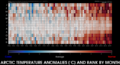
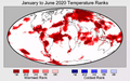 2020 record temperatures.png 800 × 502; 358 KB
 7-20-2020 GreenPolicy360 RT No.2.jpg 591 × 510; 125 KB
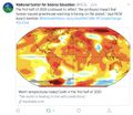
 A scorching year, what about the 360 warming data.jpg 600 × 706; 106 KB
 About website of The Invading Sea.png 800 × 343; 126 KB
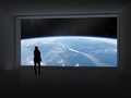 Above.png 500 × 375; 173 KB
 Acceptance on behalf of the United States of America.png 448 × 306; 62 KB
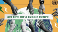 Act now for a livable future.png 501 × 275; 272 KB
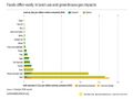 Ag production and GHG emissions.jpg 680 × 510; 33 KB
 Amazon fires burn across the rainforest.jpg 800 × 504; 76 KB
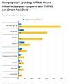 American Jobs Act compared w THRIVE Act (Green New Deal).jpg 674 × 798; 90 KB
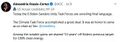 AOC re climate task force - july 8 2020.jpg 585 × 203; 38 KB
 ArcGIS-logo.png 302 × 167; 7 KB
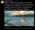 Arctic - Kolbert - 2023.png 553 × 476; 274 KB
 Arctic Melt - 1950-2020.png 640 × 349; 287 KB
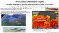 Arctic Siberia Heatwave - Again - June 2021.jpg 640 × 360; 83 KB
 Arctic-March30,2019.jpg 797 × 600; 126 KB
 Arctic-Siberia-6-20-2020.jpg 478 × 644; 148 KB


.jpg)


