Category:Earth Science from Space: Difference between revisions
Siterunner (talk | contribs) |
Siterunner (talk | contribs) |
||
| Line 10: | Line 10: | ||
'''Geoscience -- #Earth360: Eyes in the Sky, Monitoring the Earth by Satellite''' | '''Geoscience -- #Earth360: Eyes in the Sky, Monitoring the Earth by Satellite''' | ||
''' | '''Updated - August 2014''' | ||
'''Earth Imaging''' -- '''Micro-satellites''' [http://en.wikipedia.org/wiki/Miniaturized_satellite] | '''Earth Imaging''' -- '''Micro-satellites''' [http://en.wikipedia.org/wiki/Miniaturized_satellite] | ||
Revision as of 18:07, 26 August 2014
Earth Sciences from Space

Geoscience -- #Earth360: Eyes in the Sky, Monitoring the Earth by Satellite
Updated - August 2014
Earth Imaging -- Micro-satellites [1]
Nextgen #earthscience in era of #climatechange and #globalsecurity threat
Observing Global Warming with #OCO-2 Historic launch #planetcitizen mission to study #earthsatmosphere
"First Light!" [2] [3] OCO-2 tweets - https://twitter.com/IamOCO2 OCO-2 announces 'We have data!'
What monitoring a potential existential crisis looks like...spectra from #OCO-2 #Earth360 [4]
Earth observing satellites, the "Afternoon Constellation", the "A-Train" joined by #OCO-2 newly launched and historic in its mission to study global warming Orbiting Carbon Observatory
Looking closer at OCO-2 [5] [6] [7]
Earth science data is coming in and being openly distributed. Take up the challenge, perhaps with NEX here and multiple venues that are being made available for the first time.
Add your resources. With the launch of OCO-2, a 'game changer', the data of #Earth360 will grow in unprecedented ways.
Add your #PlanetCitizen talent to a future of seeing with an #EarthPOV -- #Earthdata enables informed decisions and policy
"You can manage only what you can measure"

http://www.greenpolicy360.net/w/NASA_EarthSciences,_Challenges_Public_to_Join_In
Ω
Geoscience Satellites -- Start-up companies
BlackBridge [8], Dauria [9], DigitalGlobe [10] [11] [12] GeoEye [13],
GeoOptics [14], NovaWurks [15], OmniEarth [16] [17] [18] [19]
OrbitLogic [20], PlanetiQ [21], Planet Lab [22] [23]
RapidEye [24], Skybox [25] [26] [27]
Teledyne [28], Tyvak Nano-Sat [29], Urthecast [30]

June 2014 Google Buys Skybox
[31]
[32]
[33]
[34]
[Background] June 18, 2013 Inside a Startup’s Plan to Turn a Swarm of DIY Satellites Into an All-Seeing Eye [35]
June 16, 2014 - Wall Street Journal / by Christopher Mims [36]
Amid the Crazy Valuations, Google Finds a Steal
By 2016 or so, Skybox will be able to take full images of the Earth twice a day, at a resolution that until last week was illegal to sell commercially — all with just a half-dozen satellites.
By the time its entire fleet of 24 satellites has launched in 2018, Skybox will be imaging the entire Earth at a resolution sufficient to capture, for example, real-time video of cars driving down the highway. And it will be doing it three times a day.
You might think, thanks to weather maps and the satellite view on Google Maps, that such imagery already is readily available. But because satellites were, until recently, so expensive to build and launch, that isn't the case. There are only nine satellites in orbit now that capture high resolution images for the commercial market, and their capabilities are regularly commandeered for national-security purposes by the U.S. government. That means most of the pictures of the Earth that you've seen are of poor quality and years out of date.
And yet, as I discovered when I visited Skybox recently at its modest, low-slung headquarters in Mountain View, Calif., satellite imagery isn't even the business in which the company's founders see themselves. As at Google, the business of Skybox isn't data, but knowledge.
"We think we are going to fundamentally change humanity's understanding of the economic landscape on a daily basis," says co-founder Dan Berkenstock...
Skybox's images will inevitably lead to apps and services no one can envision — with unknowable disruptive potential. Skybox executives tell me they hope to offer their data to outside developers... In the short term, Google has said it would use Skybox's images to improve the search company's maps.
A patent revealed in May indicates that Google builds its superaccurate maps directly from satellite imagery, and the company has long had a deal with Skybox competitor DigitalGlobe, whose satellites cost 10 times as much as Skybox's and are 10 times heavier, leading to much higher launch costs. DigitalGlobe's stock dipped 4% on news of the Skybox deal...
_ _ _ _ _ _ _ _ _ _ _ _ _ _ _ _ _ _ _ _ _
“With all these start-ups, the things you’ll be able to do with satellite images will grow exponentially..." - IEEE, May 2014
June 16, 2014
- U.S. Department of Commerce lifts ban on satellite images showing features smaller than 20 inches - DigitalGlobe [37] [38] [39] [40]
- "Companies had not been allowed to make use of images where features smaller than 50cm were visible"
- Satellites Are Cleared to Take Photos at Mailbox-Level Detail per DigitalGlobe petition
- Worldview-3 satellite is set to launch in August. Digital Globe [41] [42] says it will now be able to sell images that show features as small as 31cm [43]
- Sites like Google and Bing Maps will be able to use higher-quality satellite images in near real-time [44] [45]... eventually real-time
GP360: Earth-monitoring, data-sharing, open source, is in the wings...
Citizen-networking/schools-education space-earth projects, first-ever...
- 24/7 high-definition video of Earth <Urthecast-ISS> [46]
Live from the International Space Station [47] [48] [49] [50] [51]

Feb 2014 – Planet Labs
Since the launch of the original Landsat program in 1972, generating images of Earth from space has been the near-exclusive domain of enormous, multi-million dollar satellites sponsored by nations and major defense corporations.
New micro-satellites, including those launched from the ISS, aim to make real-time imaging available for a fraction of the past decades price and move us from military-defense-communication operations to earth systems-defense, monitoring, sustainability and eco-nomics functions.
Earth systems, monitoring over time - http://www.earthzine.org/geo-and-geoss-the-group-on-earth-observations-and-the-global-earth-observations-system-of-systems/
<more> http://gizmodo.com/meet-the-flockers-iss-launches-low-cost-earth-imaging-1517232660
Earth Imaging - background – 2007 - Acquiring large data sets of Earth imagery in a simple, low-cost way, represents a new market opportunity that has yet to be addressed. New telescope design enables low-cost satellite with that purpose.

Jan 2014 - "Flocking" "Doves" "Nanosatellites" - http://www.scientificamerican.com/article/flock-of-nano-satellites-to-capture-high-res-views-of-whole-earth/
Google goes mapping - http://gizmodo.com/how-swarms-of-tiny-satellites-are-creating-a-real-time-1497890594
Swarms of small satellites set to deliver close to real-time imagery - http://www.nature.com/news/many-eyes-on-earth-1.14475

Dec 2013
"How Planet Labs Is Saving the Earth with 'Homemade' Satellites. It took less than six months to build twenty-eight of them"...
<more> http://www.businessinsider.com/planet-labs-fleet-of-homemade-satellites-2013-12?op=1
http://www.space.com/23739-tiny-earth-satellite-fleet-launching-december.html
Nov 2013
Flock of Mini- and Micro-sats delivered to space with international Dnepr co-venture - http://www.space.com/23738-dnepr-rocket-launches-32-satellites.html
Minotaur 1 delivers 29 mini's/CubeSats including first-ever design/build satellite project of a US high school
http://www.orbital.com/NewsInfo/MissionUpdates/MinotaurI_ORS-3/
Sept 2013
Sensors and Systems - “Every year the technology improves, with better computers and storage and payloads. The technological evolution improves, price points continue to come down, and now with a small 150 to 300 kg spacecraft for $10 to $20 million you can do what you were doing with a 1,000 kg spacecraft five to 10 years ago for $500 million.” Surrey Satellite Technology-RapidEye satellite imagery “Changing the Economics of Space” ... co-ventures/joint ventures/'ride-alongs'/shared platforms/accessible data
<more> http://www.sstl.co.uk/ - note connection to SpaceX - Elon Musk - note Elon Muck opening up the Tesla platform on June 12, 2014 - http://en.wikipedia.org/wiki/Surrey_Satellite_Technology - http://www.teslamotors.com/blog/all-our-patent-are-belong-you
June 2013
Citizens in Space - http://www.citizensinspace.org/2013/06/planet-labs-to-launch-flock-1/
Opening up to understanding and interacting with our eco-operating systems
eOS http://www.scribd.com/doc/189078245/eOS-EcoOperatingSystem-1
_ _ _ _ _ _ _ _ _ _ _ _ _ _ _ _ _ _ _ _ _
Earth systems, monitoring over time - http://www.earthzine.org/geo-and-geoss-the-group-on-earth-observations-and-the-global-earth-observations-system-of-systems/
GEO - Group on Earth Observations - http://www.earthobservations.org/about_geo.shtml
- GEOSS - Global Earth Observation System of Systems - http://www.earthobservations.org/geoss.shtml
_ _ _ _ _ _ _ _ _ _ _ _ _ _ _ _ _ _ _ _ _ _ _ _ _ _ _ _ _ _ _ _ _ _ _ _ _ _ _ _ _

Subcategories
This category has the following 20 subcategories, out of 20 total.
A
C
D
E
G
N
O
P
S
T
W
Pages in category "Earth Science from Space"
The following 86 pages are in this category, out of 86 total.
C
- Carbon Brief
- Clearcutting
- Climate Change - Global Warming Keyword-Terms
- Climate Change Denier Talking Points -- and Rebuttals
- Climate Conference - Paris 2015
- Climate Desk
- Climate Law Blog @Columbia Law School
- Climate migration
- Climate News
- Climate News Events Archive ... 1970 to Today
- Climate Plans Enforcement - Resources
E
- Each of us can make a positive difference
- Earth
- Earth from NASA
- Earth Imaging-New Space
- Earth Right Now
- Earth Science Eco-Fields
- Earth Science Research from Space
- Earth Science Vital Signs
- EarthPOV
- EarthTime
- Earthviews
- Earthviews from Astronauts
- Environmental full-cost accounting
- Environmental Rules Rolled Back
- Environmental Security Organizations
- ESA Living Planet Announcement - May 2022
- Ethics and Climate Change
- European Union Green Deal - Fit for 55
- ExxonMobil and US House Science Committee v US Attorneys General and Environmental Groups
G
- GEOID
- George E. Brown Jr
- Glasgow Climate Summit - Pledges, Promises, Declarations - What's Next Up
- Global Climate Action Summit
- Global Fishing Watch
- Global Forest Watch
- Google Earth
- Google Earth Timelapse
- Greening Our Blue Planet
- GreenPolicy360 Archive Highlights 2021
- GreenPolicy360 Archive Highlights 2022
I
L
P
S
Media in category "Earth Science from Space"
The following 62 files are in this category, out of 862 total.
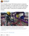
(previous page) (next page) Trump digs coal-2.jpg 800 × 533; 46 KB
 Trump guts climate policy 3-28-2017 10-26-34 AM.png 569 × 205; 36 KB
 Trump promise to oil ceo gathering - 1.png 440 × 108; 19 KB
 Trump promise to oil ceo gathering - 2.png 480 × 495; 291 KB
 Trump promise to oil ceo gathering - 3.png 480 × 284; 270 KB
 Trump promise to oil ceo gathering - 4.png 480 × 480; 333 KB
 UN - Tipping Point for Climate Action.png 690 × 600; 601 KB
 UN Climate Conf Dec2015.png 576 × 182; 42 KB
 UN Climate Summit News (1).pdf ; 1.85 MB
 UN DecinParis.png 296 × 277; 135 KB
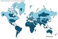
 UN Mapping the World.png 740 × 477; 584 KB
 UN NDC Registry - website database.png 798 × 392; 575 KB
 Unified sea level rise - Southeast Florida.jpg 800 × 418; 70 KB
 Unprecedented report - IPCC Aug-9-2021.jpg 800 × 666; 165 KB
 Update - James Hansen July 2023 'We are fools'.png 595 × 800; 610 KB
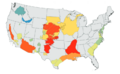
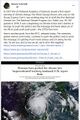
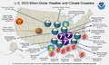 US 2020-billion-dollar-disasters-map.png 800 × 480; 259 KB
 US Annual Temperatures 1901-2020 Average Comparison.jpg 604 × 843; 242 KB
 US EPA to reverse methane rules.jpg 592 × 745; 175 KB
 US Presidential Campaign-2016 ClintonvTrump on Envir Issues.png 511 × 856; 435 KB
 US Public Law 95-367.png 732 × 469; 149 KB
 US Quits Climate Accord.jpg 795 × 233; 40 KB
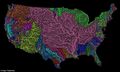 US River basins - watersheds.jpg 800 × 477; 131 KB
- US Role George E Brown 2.pdf ; 151 KB
- US Role George E Brown 3.pdf ; 157 KB
 US Senate passes 430 billion climate bill.png 468 × 396; 213 KB
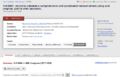
 Usable climate science is adaptation science-Adam Sobel May 2021.jpg 702 × 664; 155 KB
 USGS Groundwater depletion map 2013.png 794 × 490; 238 KB
 Venice flooding.png 530 × 516; 109 KB
 Virginia Norwood - 1948.jpg 640 × 426; 74 KB
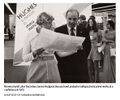 Virginia Tower Norwood and James Hodgson - 1972.jpg 589 × 489; 69 KB
 Virtual Earth cover.png 800 × 479; 833 KB
 Vital signs 1.png 853 × 507; 362 KB
 Water shortage 4B people sci report-2016.png 853 × 233; 148 KB
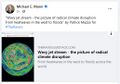 Wavy Jet Stream by Patrick Mazza.jpg 515 × 362; 64 KB
 We are all in this together-IPCC report-August 2021.jpg 513 × 768; 183 KB
 We must flatten the curve, yes ... August 2020.jpg 800 × 421; 99 KB
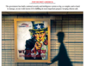 We Want You Security State investigation WaPo.png 612 × 480; 645 KB
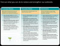 Wetlands - Wetlands Day.png 640 × 492; 333 KB
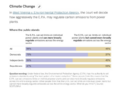
 What happens when.png 585 × 215; 20 KB
 Wheeler-Mulvaney-repeal of Clean Power Plan-June19,2019.jpg 800 × 640; 145 KB
 When your house is on fire.jpg 589 × 473; 77 KB
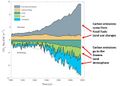 Where carbon emission come from - gleick tw 2018.jpg 640 × 460; 41 KB
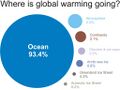 Where is global warming.jpg 1,024 × 768; 51 KB
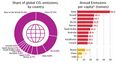 Which countries pollute the most ~2017.jpg 800 × 422; 69 KB
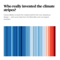 Who really invented the climate stripes - Climate Change Education.png 600 × 600; 234 KB
 Whole Earth Catalog-Internet Archive-4-23-2021.jpg 592 × 305; 48 KB
 Why is the Amazon burning - Katharine Hayhoe explains.jpg 498 × 763; 149 KB
 Wiki IPCC m.jpg 602 × 339; 112 KB
 Wildfires 2021 - August.jpg 519 × 220; 54 KB
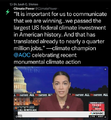 Winning on the climate legis - AOC.png 480 × 519; 249 KB
 World Map - Mercator projection v Google maps.jpg 800 × 545; 101 KB
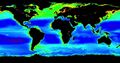 Worldwide view of plankton www.phys.org.jpg 378 × 200; 138 KB
 WV v EPA SCOTUS poll - June 27 2022 before court decision.png 623 × 480; 126 KB
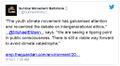 Youth Climate Movement.jpg 516 × 284; 79 KB
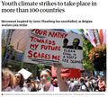 Youth Climate Strikes-March15,2019.jpg 707 × 639; 159 KB
 Zack Labe - climate viz - June 2024.png 675 × 600; 261 KB


