File:NASA has a new mission... against Methane.png: Difference between revisions
Siterunner (talk | contribs) No edit summary |
Siterunner (talk | contribs) No edit summary |
||
| Line 6: | Line 6: | ||
:* https://www.nasa.gov/feature/jpl/methane-super-emitters-mapped-by-nasa-s-new-earth-space-mission | :* https://www.nasa.gov/feature/jpl/methane-super-emitters-mapped-by-nasa-s-new-earth-space-mission | ||
:* https://www.greenpolicy360.net/w/File:NASA_has_a_new_mission..._against_Methane.png | |||
Revision as of 12:08, 1 November 2022
GreenPolicy360: Methane hot spots we're coming to find you, identify you, act to stop you and enforce climate laws.
- "Super emitters", we have a message for you, you can't hide....
🌎
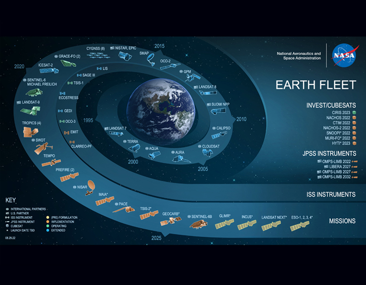
Detecting the presence of methane, a potent greenhouse gas
The International Space Station in July, the science team has identified more than 50 “super-emitters” in Central Asia, the Middle East, and the Southwestern United States. Super-emitters are facilities, equipment, and other infrastructure, typically in the fossil-fuel, waste, or agriculture sectors, that emit methane at high rates.
“Reining in methane emissions is key to limiting global warming. This exciting new development will not only help researchers better pinpoint where methane leaks are coming from, but also provide insight on how they can be addressed – quickly,” said NASA Administrator Bill Nelson. “The International Space Station and NASA’s more than two dozen satellites and instruments in space have long been invaluable in determining changes to the Earth’s climate. EMIT is proving to be a critical tool in our toolbox to measure this potent greenhouse gas – and stop it at the source.”
Methane absorbs infrared light in a unique pattern – called a spectral fingerprint. NASA's EMIT imaging spectrometer can discern with high accuracy and precision. The instrument can also measure carbon dioxide.
The new observations stem from the broad coverage of the planet afforded by the space station’s orbit, as well as from EMIT’s ability to scan swaths of Earth’s surface dozens of miles wide while resolving areas as small as a soccer field.
“These results are exceptional, and they demonstrate the value of pairing global-scale perspective with the resolution required to identify methane point sources, down to the facility scale,” said David Thompson, EMIT’s instrument scientist and a senior research scientist at NASA’s Jet Propulsion Laboratory in Southern California, which manages the mission. “It’s a unique capability that will raise the bar on efforts to attribute methane sources and mitigate emissions from human activities.”
🌎
More at GreenPolicy360
GreenPolicy360's Campaign to 'Turn National Climate Promises & Pledges into Reality'
- Our Climate Plans Enforcement Initiative continues as the next Global Climate Conference approaches, November's Conference of the Parties (COP27)
- Drawing from the database of Earth Science resulting from decades of space-based missions designed to provide us with actionable 'Earth-system and Climate-related data'
- Measuring and Monitoring to better manage Earth's Living, Dynamic and Changing Systems, Local, National and Global
Methods to Enforce Climate Plan Pledges
GreenPolicy360: Climate Plans Enforcement Initiative
Pressuring Nations to Step Up, Cooperate, and Act Now
Environmental Laws, Regs, Rules... Lawsuits & Legal Actions
Glasgow (2021) & Paris (2015) Summits: Int'l Climate Plan Pledges & Promises (INDCs-NDCs)
Decades of Earth Science/Climate Science Data Accessible for Planet Citizen Action
🌎
File history
Click on a date/time to view the file as it appeared at that time.
| Date/Time | Thumbnail | Dimensions | User | Comment | |
|---|---|---|---|---|---|
| current | 11:57, 1 November 2022 |  | 800 × 576 (681 KB) | Siterunner (talk | contribs) |
You cannot overwrite this file.
File usage
The following 14 pages use this file:
- Climate News
- Climate Plans Enforcement - Resources
- Climate Problems, Climate Solutions
- Earth Imaging-New Space
- Earth and Space, Politics
- GreenPolicy360 Archive Highlights 2022
- GreenPolicy360 Archive Highlights 2023
- Green New Deal
- Green Stories of the Day
- File:Global Stocktake, the first GST.jpg
- File:Methane Reduction proposal passes in EU Parliament - May 2023.png
- File:Methods to enforce climate pledges-NDCs - Dec 2021.png
- File:Monitoring Greenhouse Gases from Satellite Missions 2021-2030.png
- Category:Climate Policy
- About Us
- Additional Website Resources - Linked Data - Green Best Practices
- Alternative Agriculture
- Anthropocene
- Arctic
- Atmospheric Science
- Biodiversity
- Bioneers
- Biosphere
- Citizen Science
- City Governments
- City-County Governments
- Civil Rights
- Clean Air
- Clean Water
- Climate Change
- Climate Policy
- County Governments
- Democratization of Space
- Digital Citizen
- Digital Rights
- Earth
- Eco-nomics
- Earth Day
- Earth Imaging
- Earth Observations
- EOS eco Operating System
- Earth360
- EarthPOV
- Earth Science
- Ecofeminism
- Ecology Studies
- Ecological Economics
- Economic Justice
- Education
- Election System Reform
- Energy
- Environmental Full-cost Accounting
- Environmental Laws
- Environmental Protection
- Environmental Security
- Environmental Security, National Security
- ESA
- Externalities
- Food
- Greenland
- Global Security
- Global Warming
- Green Best Practices
- Green Networking
- Green Graphics
- Green Politics
- Health
- Human Rights
- Internet
- ISS
- Labor Issues
- Micro-satellites
- Microbiology
- Microorganism
- Money in Politics
- NASA
- Natural Resources
- Natural Rights
- Networking
- New Definitions of National Security
- New Space
- Ordinances
- Overview Effect
- Peace
- Planet Citizen
- Planet Citizens
- PlanetLabs
- Planet Scientist
- Planet Citizens, Planet Scientists
- Renewable Energy
- Resilience
- Sea-level Rise
- Sea-Level Rise & Mitigation
- Seventh Generation Sustainability
- Social Justice
- Solar Energy
- State
- Strategic Demands
- Sustainability
- Sustainability Policies
- ThinBlueLayer
- US Environmental Protection Agency
- Water Quality
- Whole Earth
- Wildlife
- World Wide Web
- Youth
