File:Landsat Image Gallery.jpg: Difference between revisions
Siterunner (talk | contribs) No edit summary |
Siterunner (talk | contribs) No edit summary |
||
| (2 intermediate revisions by the same user not shown) | |||
| Line 1: | Line 1: | ||
<big><big>'''Landsat Image Gallery'''</big></big> | |||
* https://landsat.gsfc.nasa.gov/landsat-galleries | |||
* https://landsat.visibleearth.nasa.gov/ | |||
| Line 14: | Line 21: | ||
Read more about Landsat | |||
* https://www.greenpolicy360.net/w/LANDSAT_and_Virginia_Tower_Norwood | * https://www.greenpolicy360.net/w/LANDSAT_and_Virginia_Tower_Norwood | ||
| Line 62: | Line 61: | ||
[[Category:Global Warming]] | [[Category:Global Warming]] | ||
[[Category:Green Graphics]] | [[Category:Green Graphics]] | ||
[[Category:GreenPolicy360 | [[Category:GreenPolicy360]] | ||
[[Category:Maps]] | [[Category:Maps]] | ||
[[Category:NASA]] | [[Category:NASA]] | ||
Latest revision as of 20:17, 12 July 2021
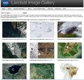
Landsat Image Gallery
GreenPolicy360 Siterunner: In the late 1960s and early 70s, Congressman George Brown on the Space and Technology Committee was pressing forward with NASA's development of the first array of earth science satellite missions. Near the top of his list of project missions was LANDSAT 1.
Representative Brown was out in front of "Big Science". In his decades on the House Science, Space & Technology Committee, he worked to expand the reach of science. He knew that good data enabled good policy decisions. He pressed for first-generation earth science satellites and ongoing earth monitoring missions and data sharing.
Among his many initiatives, George Brown was a key figure in proposing, establishing, and then saving the Landsat program and its unique 'open-access' database of Earth Science imaging when President Reagan attempted to shut Landsat down. Landsat was a model for all the following earth science research missions from space and is now moving into its fifth decade with Landsat 9.
Read more about Landsat
~
File history
Click on a date/time to view the file as it appeared at that time.
| Date/Time | Thumbnail | Dimensions | User | Comment | |
|---|---|---|---|---|---|
| current | 16:32, 12 July 2021 |  | 800 × 766 (187 KB) | Siterunner (talk | contribs) |
You cannot overwrite this file.
File usage
The following 3 pages use this file:
- Atmosphere
- Atmospheric Science
- Biodiversity
- Citizen Science
- Clean Air
- Clean Water
- Climate Change
- Climate Policy
- Earth
- Earth360
- EarthPOV
- Earth Day
- Earth Imaging
- Earth Observations
- Earth Science
- Earth Science from Space
- Earth System Science
- Eco-nomics
- Ecological Economics
- Ecology Studies
- Environmental Laws
- Environmental Protection
- Environmental Security
- Environmental Security, National Security
- EOS eco Operating System
- Global Security
- Global Warming
- Green Graphics
- GreenPolicy360
- Maps
- NASA
- New Definitions of National Security
- NOAA
- Oceans
- Planet Citizen
- Planet Citizens
- Planet Citizens, Planet Scientists
- Pollution
- Resilience
- Rivers
- Strategic Demands
- Sustainability
- Sustainability Policies
- Toxics and Pollution
- US Environmental Protection Agency
- Water Quality
- Whole Earth