Category:Watersheds: Difference between revisions
Siterunner (talk | contribs) No edit summary |
Siterunner (talk | contribs) No edit summary |
||
| (2 intermediate revisions by the same user not shown) | |||
| Line 2: | Line 2: | ||
[[File:Featured.png]] | [[File:Featured.png]] | ||
We all live in a watershed. What's your watershed? | We all live in a watershed. What's your watershed? | ||
| Line 17: | Line 18: | ||
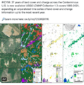
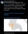
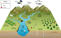
[[File:Watershed monitoring earthscience m.png]] | ::::[[File:Watershed monitoring earthscience m.png]] | ||
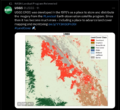
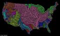
[[File:US River basins - watersheds.jpg]] | [[File:US River basins - watersheds.jpg]] | ||
US Watersheds / River Basins - Drainage Basins | |||
| Line 33: | Line 35: | ||
Read More | Read More | ||
:http://www.dailymail.co.uk/sciencetech/article-3860062/The-veins-America-Stunning-map-shows-river-basin-US.html | |||
:http://www.greenpolicy360.net/w/Landsat_data_users_handbook | :* http://www.dailymail.co.uk/sciencetech/article-3860062/The-veins-America-Stunning-map-shows-river-basin-US.html | ||
:* http://www.greenpolicy360.net/w/Landsat_data_users_handbook | |||
Latest revision as of 20:00, 13 June 2024

We all live in a watershed. What's your watershed?
A drainage basin or catchment basin is an extent or an area of land where surface water from rain, melting snow, or ice converges to a single point at a lower elevation, usually the exit of the basin, where the waters join another waterbody, such as a river, lake, reservoir, estuary, wetland, sea, or ocean. For example, a tributary stream of a brook that joins a small river is tributary of a larger river, which is thus part of a series of successively smaller area but higher elevation drainage basins. Similarly, the Missouri and Ohio rivers are each part of their own drainage basins and that of the Mississippi River.
Other terms that are used to describe drainage basins are catchment, catchment area, drainage area, river basin and water basin. In North America, the term watershed is commonly used to mean a drainage basin, though in other English-speaking countries, it is used only in its original sense, to mean a drainage divide, the former meaning an area, the latter the high elevation perimeter of that area. Drainage basins drain into other drainage basins in a hierarchical pattern, with smaller sub-drainage basins combining into larger drainage basins...


US Watersheds / River Basins - Drainage Basins
River Basins-Watershed Maps avail at GrasshopperGeography - https://www.etsy.com/shop/GrasshopperGeography?section_id=20096462
US Maps created by Imgur user Fejetlenfej
Visit http://imgur.com/gallery/N4cUA for US mapping
Open-source QGIS software -- http://qgis.org/en/site/
Read More
~
Pages in category "Watersheds"
The following 7 pages are in this category, out of 7 total.
Media in category "Watersheds"
The following 36 files are in this category, out of 36 total.
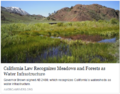 AB 2480 Meadows and Forest Water Infrastructure.png 481 × 375; 248 KB
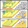
 About Baselines and Change.png 592 × 312; 33 KB
 Bill Mollison 1928-2016.pdf ; 99 KB
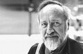 Bill Mollison courtesy of Permaculture magazine.jpg 460 × 300; 0 bytes
 Bill Mollison the day after his passing memories.png 1,381 × 651; 1.65 MB
 California's kelp forests and coastal biodiversity diminished.png 532 × 754; 307 KB
 Celebrating 50 Years of Landsat.png 600 × 610; 909 KB
 Florida via NASA 2022.png 800 × 1,020; 1.12 MB
 Florida Wildlife Corridor - 2022 illustration.png 800 × 628; 473 KB
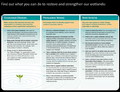
 Florida Wildlife Corridor FLWC Water Benefits December 2022.png 768 × 886; 109 KB
 Hindu Kush-Himalayas - 2023 Report on Dangerous Climate Impacts.png 800 × 819; 1,023 KB
 Land Remote Sensing Policy Act of 1992.jpg 563 × 480; 144 KB
 Landsat band imagery2.png 800 × 400; 907 KB
 Landsat data site.png 657 × 600; 499 KB
 Landsat launched 50 years ago today.png 528 × 779; 755 KB
 Landsat NASA - Feb 11 2023.png 763 × 600; 578 KB
 Landsat US collection of maps 1985-2021.png 768 × 775; 1,018 KB
 Landsat, a 50 year legacy.png 528 × 575; 288 KB
 Mangroves and Coastal Wetlands tracked by Landsat.png 600 × 716; 245 KB
 OaklandWastewater plant.jpg 800 × 399; 125 KB
 Permaculture-observation tip.jpg 480 × 540; 86 KB
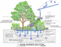 Rain Garden Design courtesy of www.PermaDesign.com Nate Downey.png 800 × 614; 601 KB
 River basins - watersheds.jpg 800 × 214; 111 KB
 Secret Life of Rivers.png 800 × 451; 800 KB
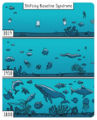 Shifting Baseline Syndrome - threats to ecosystems biodiversity.png 431 × 534; 322 KB
 Shifting Baselines 2.jpg 600 × 600; 140 KB
 Toby Hemenway-RIP Dec2016.png 503 × 327; 32 KB
 US River basins - watersheds.jpg 800 × 477; 131 KB
 USA-satellitemap.jpg 794 × 496; 232 KB
 Water Action News - March 2023.png 640 × 277; 103 KB
 WaterAction - 2023.PNG 480 × 640; 300 KB
 Watershed monitoring earthscience l.png 1,430 × 900; 462 KB
 Watershed monitoring earthscience m.png 572 × 360; 143 KB
 Wetlands - Wetlands Day.png 640 × 492; 333 KB


- Agricultural Economics
- Agriculture
- Climate Change
- Climate Policy
- Democratization of Space
- Earth360
- EarthPOV
- Earth Art
- Earth Observations
- Earth Science
- Earth Science from Space
- Environmental Protection
- Global Security
- NASA
- New Space
- Planet API
- Planet Citizen
- Planet Citizens, Planet Scientists
- Virtual Earth
- Whole Earth
- Alternative Agriculture
- Aquifers
- Appropriate Technology
- Biodiversity
- Bioneers
- Biogeosciences
- Bioregionalism
- Eco-nomics
- Ecology Studies
- Ecoregions
- EOS eco Operating System
- Farm-Related Policies
- Food
- Food-Related Policies
- Green Best Practices
- Land Ethic
- Permaculture
- Resilience
- Soil
- Sustainability
- Sustainability Policies
- US
- Virtual Planet
- Water
- Watersheds
- Wetlands