File:Forests change between 2000 and 2012.jpg: Difference between revisions
Siterunner (talk | contribs) No edit summary |
Siterunner (talk | contribs) No edit summary |
||
| Line 1: | Line 1: | ||
HIGH-RESOLUTION GLOBAL MAPS OF 21ST-CENTURY FOREST COVER CHANGE | |||
http://www.sciencemag.org/content/342/6160/850.full.pdf?sid=79d34961-a110-424d-877b-0794f8c52f62 | |||
Quantification of global forest change has been lacking despite the recognized importance of forest ecosystem services. In this study, Earth observation satellite data were used to map global forest loss (2.3 million square kilometers) and gain (0.8 million square kilometers) from 2000 to 2012 at a spatial resolution of 30 meters. The tropics were the only climate domain to exhibit a trend, with forest loss increasing by 2101 square kilometers per year. Brazil’s well-documented reduction in deforestation was offset by increasing forest loss in Indonesia, Malaysia, Paraguay, Bolivia, Zambia, Angola, and elsewhere. Intensive forestry practiced within subtropical forests resulted in the highest rates of forest change globally. Boreal forest loss due largely to fire and forestry was second to that in the tropics in absolute and proportional terms. These results depict a globally consistent and locally relevant record of forest change. | |||
_ _ _ _ | |||
http://news.nationalgeographic.com/news/maps-from-space-show-world-s-disappearing-forests/ | http://news.nationalgeographic.com/news/maps-from-space-show-world-s-disappearing-forests/ | ||
| Line 5: | Line 13: | ||
Landsat satellite data reveal that nearly three times more forest cover was lost than gained worldwide in the 21st century... | Landsat satellite data reveal that nearly three times more forest cover was lost than gained worldwide in the 21st century... | ||
_ _ _ _ | |||
http://www.sciencemag.org/content/344/6187/981.4.full.pdf?sid=79d34961-a110-424d-877b-0794f8c52f62 | http://www.sciencemag.org/content/344/6187/981.4.full.pdf?sid=79d34961-a110-424d-877b-0794f8c52f62 | ||
| Line 11: | Line 22: | ||
crops, which leads to a substantial underestimate of forest loss and compromises its value for local policy decisions. | crops, which leads to a substantial underestimate of forest loss and compromises its value for local policy decisions. | ||
The high-resolution global map of forest cover loss and gain in Hansen et al. (1) is a fascinating and much-needed tool for both | The high-resolution global map of forest cover loss and gain in Hansen et al. (1) is a fascinating and much-needed tool for both research and conservation planning. The authors claim that “[t]he information content of the presented data sets... provides a transparent, sound, and consistent basis on which to quantify critical environmental issues, including...(iv) the status of remaining natural forests of the world and threats to biodiversity…(v) the effectiveness of existing protected-area networks…(vi) the economic drivers of natural forest conversion to more intensive land uses.” After studying the supplementary data application (http://earthenginepartners.appspot.com/science-2013-global-forest) in detail, we express serious concerns about the appropriateness of the product for these purposes. | ||
research and conservation planning. The authors claim that “[t]he information content of the presented data sets...provides a transparent, sound, and consistent basis on which to quantify critical environmental issues, including...(iv) the status of remaining natural forests of the world and threats to biodiversity…(v) the effectiveness of existing protected-area networks… | |||
(vi) the economic drivers of natural forest conversion to more intensive land uses.” After studying the supplementary data application (http://earthenginepartners.appspot.com/science-2013-global-forest) in detail, we express serious concerns about the appropriateness of the product for these purposes. | |||
The main problem lies in Hansen et al.’s definition of forest as “all vegetation taller than 5min height” [supplementary materials for (1)]. Such a structural definition includes types of plantations that have already replaced substantial parts of tropical (and also extratropical) forests. Monocultures of oil palm, rubber, or Eucalyptus are recognized as some of the biggest threats to tropical biodiversity (2–4), and their expansion into forest systems continues at an alarming rate[see (5) for details]. Although these plantations are technically “forests” in the definition above, they do not provide the benefits of forest vegetation as enumerated by the authors—i.e., “ecosystem services, including biodiversity richness, climate regulation, carbon storage, and water supplies” (6–9). Classifying plantations as forests confuses an endangered habitat with its greatest threats and thus underestimates real forest loss. | The main problem lies in Hansen et al.’s definition of forest as “all vegetation taller than 5min height” [supplementary materials for (1)]. Such a structural definition includes types of plantations that have already replaced substantial parts of tropical (and also extratropical) forests. Monocultures of oil palm, rubber, or Eucalyptus are recognized as some of the biggest threats to tropical biodiversity (2–4), and their expansion into forest systems continues at an alarming rate[see (5) for details]. Although these plantations are technically “forests” in the definition above, they do not provide the benefits of forest vegetation as enumerated by the authors—i.e., “ecosystem services, including biodiversity richness, climate regulation, carbon storage, and water supplies” (6–9). Classifying plantations as forests confuses an endangered habitat with its greatest threats and thus underestimates real forest loss. | ||
Revision as of 16:32, 6 August 2015
HIGH-RESOLUTION GLOBAL MAPS OF 21ST-CENTURY FOREST COVER CHANGE
http://www.sciencemag.org/content/342/6160/850.full.pdf?sid=79d34961-a110-424d-877b-0794f8c52f62
Quantification of global forest change has been lacking despite the recognized importance of forest ecosystem services. In this study, Earth observation satellite data were used to map global forest loss (2.3 million square kilometers) and gain (0.8 million square kilometers) from 2000 to 2012 at a spatial resolution of 30 meters. The tropics were the only climate domain to exhibit a trend, with forest loss increasing by 2101 square kilometers per year. Brazil’s well-documented reduction in deforestation was offset by increasing forest loss in Indonesia, Malaysia, Paraguay, Bolivia, Zambia, Angola, and elsewhere. Intensive forestry practiced within subtropical forests resulted in the highest rates of forest change globally. Boreal forest loss due largely to fire and forestry was second to that in the tropics in absolute and proportional terms. These results depict a globally consistent and locally relevant record of forest change.
_ _ _ _
http://news.nationalgeographic.com/news/maps-from-space-show-world-s-disappearing-forests/
Maps From Space Show World's Disappearing Forests
Landsat satellite data reveal that nearly three times more forest cover was lost than gained worldwide in the 21st century...
_ _ _ _
http://www.sciencemag.org/content/344/6187/981.4.full.pdf?sid=79d34961-a110-424d-877b-0794f8c52f62
Hansen et al. (Reports, 15 November 2013, p. 850) published a high-resolution global forest map with detailed information on local forest loss and gain. We show that their product does not distinguish tropical forests from plantations and even herbaceous crops, which leads to a substantial underestimate of forest loss and compromises its value for local policy decisions.
The high-resolution global map of forest cover loss and gain in Hansen et al. (1) is a fascinating and much-needed tool for both research and conservation planning. The authors claim that “[t]he information content of the presented data sets... provides a transparent, sound, and consistent basis on which to quantify critical environmental issues, including...(iv) the status of remaining natural forests of the world and threats to biodiversity…(v) the effectiveness of existing protected-area networks…(vi) the economic drivers of natural forest conversion to more intensive land uses.” After studying the supplementary data application (http://earthenginepartners.appspot.com/science-2013-global-forest) in detail, we express serious concerns about the appropriateness of the product for these purposes.
The main problem lies in Hansen et al.’s definition of forest as “all vegetation taller than 5min height” [supplementary materials for (1)]. Such a structural definition includes types of plantations that have already replaced substantial parts of tropical (and also extratropical) forests. Monocultures of oil palm, rubber, or Eucalyptus are recognized as some of the biggest threats to tropical biodiversity (2–4), and their expansion into forest systems continues at an alarming rate[see (5) for details]. Although these plantations are technically “forests” in the definition above, they do not provide the benefits of forest vegetation as enumerated by the authors—i.e., “ecosystem services, including biodiversity richness, climate regulation, carbon storage, and water supplies” (6–9). Classifying plantations as forests confuses an endangered habitat with its greatest threats and thus underestimates real forest loss.
File history
Click on a date/time to view the file as it appeared at that time.
| Date/Time | Thumbnail | Dimensions | User | Comment | |
|---|---|---|---|---|---|
| current | 15:41, 6 August 2015 | 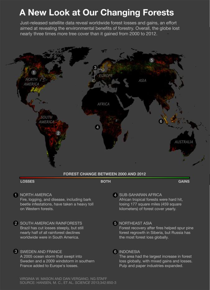 | 676 × 932 (71 KB) | Siterunner (talk | contribs) | Category:Atmospheric Science Category:Citizen Science Category:Climate Change Category:Earth360 Category:EarthPOV Category:Earth Science Category:Ecology Studies Category:Environmental Full-cost Accounting [[Category:En... |
You cannot overwrite this file.
File usage
The following 2 pages use this file:
- Atmospheric Science
- Citizen Science
- Climate Change
- Earth360
- EarthPOV
- Earth Science
- Ecology Studies
- Environmental Full-cost Accounting
- Environmental Protection
- Environmental Security
- Environmental Security, National Security
- EOS eco Operating System
- Externalities
- Forests
- Green Graphics
- Planet Citizen
- Planet Scientist
- Planet Citizens, Planet Scientists
- Planetary Science
- Renewable Energy
- Sea-level Rise
- Sea-Level Rise & Mitigation
- Sustainability
- Sustainability Policies
- ThinBlueLayer
- Virtual Earth
- Virtual Planet
- Whole Earth