File:Recent Satellite Imagery of Earth - via Azavea.png: Difference between revisions
Jump to navigation
Jump to search
Siterunner (talk | contribs) No edit summary |
Siterunner (talk | contribs) No edit summary |
||
| (7 intermediate revisions by the same user not shown) | |||
| Line 1: | Line 1: | ||
'''Available Satellite Imagery - [http://www.planetcitizen.org Planet Citizen Navigation] (circa 2022)''' | |||
* https://www.azavea.com/blog/2020/01/02/how-to-find-the-most-recent-satellite-imagery/ | |||
🌎 | |||
'''Google Earth''' | |||
* https://earth.google.com/web/ | |||
'''Bing Maps Aerial''' | |||
* https://www.arcgis.com/home/webmap/viewer.html?webmap=8651e4d585654f6b955564efe44d04e5#! | |||
'''Mapbox Satellite Live''' | |||
* https://www.mapbox.com/maps/satellite | |||
* https://www.mapbox.com/imagery | |||
'''HERE WeGo - Map View / Satellite''' | |||
* https://www.here.com/ - https://wego.here.com | |||
'''Zoom Earth''' | |||
* https://zoom.earth/ | |||
~ | |||
'''Maxxar''' | |||
* https://www.maxar.com/ | |||
'''Airbus''' | |||
* https://www.airbus.com/en | |||
'''Hexagon Geospatial''' | |||
* https://hexagon.com/solutions/geospatial-content | |||
'''Vexcel Imaging''' | |||
* https://www.vexcel-imaging.com/ | |||
'''EagleView''' | |||
* https://www.eagleview.com/ | |||
'''Nearmap''' | |||
* https://www.nearmap.com/us/en | |||
'''Planet''' | '''[[Planet API]]''' | |||
* https://www.planet.com/ | |||
* https://developers.planet.com/docs/data/skysat/ | |||
* https://earth.esa.int/eogateway/missions/skysat | |||
🌎 | |||
[[Category:Arctic]] | |||
[[Category:Atmosphere]] | |||
[[Category:Biodiversity]] | |||
[[Category:Climate Change]] | |||
[[Category:Climate Policy]] | |||
[[Category:Digital Citizen]] | |||
[[Category:Earth360]] | |||
[[Category:Earth Imaging]] | |||
[[Category:Earth Law]] | |||
[[Category:Earth Observations]] | |||
[[Category:Earth Science]] | |||
[[Category:Earth Science from Space]] | |||
[[Category:Earth System Science]] | |||
[[Category:Eco-nomics]] | |||
[[Category:Eco-Spirituality]] | |||
[[Category:Ecology Studies]] | |||
[[Category:Ecoregions]] | |||
[[Category:Education]] | |||
[[Category:Environmental Full-cost Accounting]] | |||
[[Category:Environmental Security]] | |||
[[Category:Environmental Security, National Security]] | |||
[[Category:EOS eco Operating System]] | |||
[[Category:ESA]] | |||
[[Category:Externalities]] | |||
[[Category:Fisheries]] | |||
[[Category:Forests]] | |||
[[Category:Food-Related Policies]] | |||
[[Category:Global Security]] | |||
[[Category:Global Warming]] | |||
[[Category:Green Graphics]] | |||
[[Category:ISS]] | |||
[[Category:Land Ethic]] | |||
[[Category:Maps]] | |||
[[Category:NASA]] | |||
[[Category:Natural Resources]] | |||
[[Category:New Definitions of National Security]] | |||
[[Category:New Space]] | |||
[[Category:NOAA]] | |||
[[Category:Oceans]] | |||
[[Category:Ocean Ecosystem]] | |||
[[Category:Ocean Science]] | |||
[[Category:Ocean Sustainability]] | |||
[[Category:Planet Citizen]] | |||
[[Category:Planet Citizens]] | |||
[[Category:Planet Scientist]] | |||
[[Category:Planet Citizens, Planet Scientists]] | |||
[[Category:Sea-Level Rise & Mitigation]] | |||
[[Category:Soil]] | |||
[[Category:Solar Energy]] | |||
[[Category:Strategic Demands]] | |||
[[Category:Sustainability]] | |||
[[Category:Sustainability Policies]] | |||
[[Category:ThinBlueLayer]] | |||
[[Category:Threat Multiplier]] | |||
[[Category:US Environmental Protection Agency]] | |||
[[Category:Whole Earth]] | |||
[[Category:World Wide Web]] | |||
[[Category:Atmospheric Science]] | |||
[[Category:Biogeosciences]] | |||
[[Category:Cryosphere]] | |||
[[Category:Geophysics and Geochemistry]] | |||
[[Category:Mineralogy]] | |||
[[Category:Geology]] | |||
[[Category:Geophysics]] | |||
[[Category:Hydrology]] | |||
[[Category:Natural Resources]] | |||
[[Category:Ocean Science]] | |||
[[Category:Planetary Science]] | |||
[[Category:Space Science and Space Physics]] | |||
Latest revision as of 20:58, 3 June 2023
Available Satellite Imagery - Planet Citizen Navigation (circa 2022)
🌎
Google Earth
Bing Maps Aerial
Mapbox Satellite Live
HERE WeGo - Map View / Satellite
Zoom Earth
~
Maxxar
Airbus
Hexagon Geospatial
Vexcel Imaging
EagleView
Nearmap
Planet | Planet API
- https://www.planet.com/
- https://developers.planet.com/docs/data/skysat/
- https://earth.esa.int/eogateway/missions/skysat
🌎
File history
Click on a date/time to view the file as it appeared at that time.
| Date/Time | Thumbnail | Dimensions | User | Comment | |
|---|---|---|---|---|---|
| current | 13:55, 14 May 2023 | 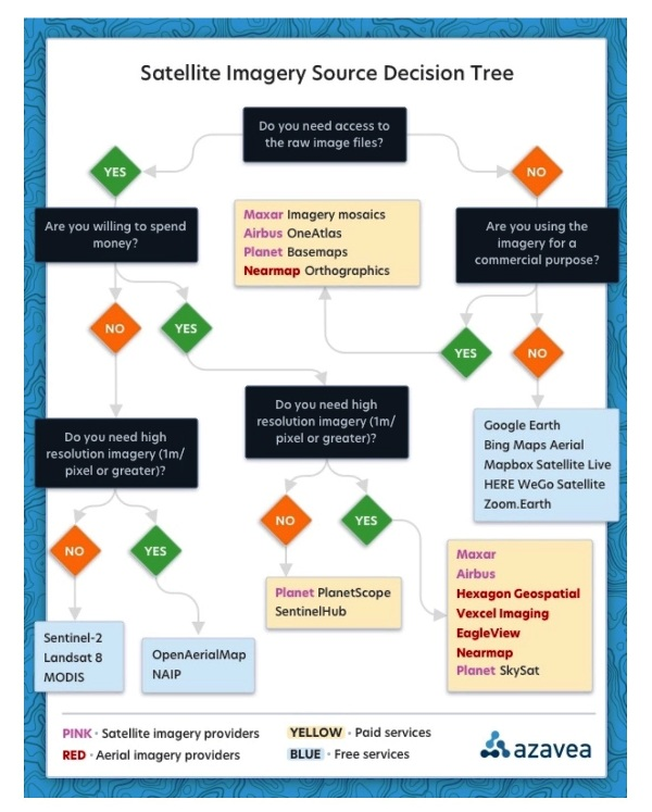 | 600 × 747 (488 KB) | Siterunner (talk | contribs) |
You cannot overwrite this file.
File usage
The following 6 pages use this file:
Categories:
- Arctic
- Atmosphere
- Biodiversity
- Climate Change
- Climate Policy
- Digital Citizen
- Earth360
- Earth Imaging
- Earth Law
- Earth Observations
- Earth Science
- Earth Science from Space
- Earth System Science
- Eco-nomics
- Eco-Spirituality
- Ecology Studies
- Ecoregions
- Education
- Environmental Full-cost Accounting
- Environmental Security
- Environmental Security, National Security
- EOS eco Operating System
- ESA
- Externalities
- Fisheries
- Forests
- Food-Related Policies
- Global Security
- Global Warming
- Green Graphics
- ISS
- Land Ethic
- Maps
- NASA
- Natural Resources
- New Definitions of National Security
- New Space
- NOAA
- Oceans
- Ocean Ecosystem
- Ocean Science
- Ocean Sustainability
- Planet Citizen
- Planet Citizens
- Planet Scientist
- Planet Citizens, Planet Scientists
- Sea-Level Rise & Mitigation
- Soil
- Solar Energy
- Strategic Demands
- Sustainability
- Sustainability Policies
- ThinBlueLayer
- Threat Multiplier
- US Environmental Protection Agency
- Whole Earth
- World Wide Web
- Atmospheric Science
- Biogeosciences
- Cryosphere
- Geophysics and Geochemistry
- Mineralogy
- Geology
- Geophysics
- Hydrology
- Planetary Science
- Space Science and Space Physics