File:Suomi satellite 2014.png: Difference between revisions
Suomi_satellite_2014.png (512 × 506 pixels, file size: 472 KB, MIME type: image/png)
Siterunner (talk | contribs) No edit summary |
Siterunner (talk | contribs) No edit summary |
||
| (2 intermediate revisions by the same user not shown) | |||
| Line 1: | Line 1: | ||
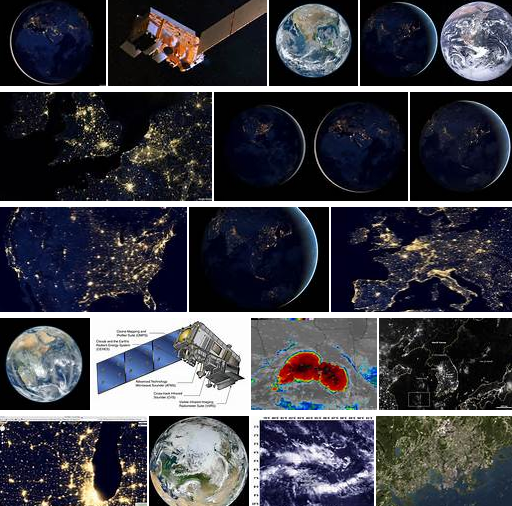
The Suomi NPP is the first in a new generation of satellites intended to replace the [https://en.wikipedia.org/wiki/Earth_Observing_System '''Earth Observing System satellites'''], which were launched from 1997 to 2011. | The Suomi NPP is the first in a new generation of satellites intended to replace the [https://en.wikipedia.org/wiki/Earth_Observing_System '''Earth Observing System satellites'''], which were launched from 1997 to 2011. | ||
* https://en.wikipedia.org/wiki/Earth_Observing_System | * https://en.wikipedia.org/wiki/Earth_Observing_System | ||
* https://en.wikipedia.org/wiki/Suomi_NPP | * https://en.wikipedia.org/wiki/Suomi_NPP | ||
The satellite orbits the Earth about 14 times each day. Suomi's instruments provide climate measurements that continue prior observations by NASA's Earth Observing System (EOS). | |||
The NPOESS Preparatory Project (NPP) of Suomi is intended to bridge the gap between old Earth Observing System (EOS) and new systems (JPSS) by flying new instruments, on a new satellite bus, using a new ground data network. | |||
Originally planned for launch five years earlier as a joint NASA/NOAA/DoD project, NPP was to be a pathfinder mission for the larger National Polar-orbiting Operational Environmental Satellite System (NPOESS) until DoD participation in the larger project was dissolved. The project continued as a civilian weather forecasting replacement for the NOAA Polar Operational Environmental Satellites (POES) series, and ensured continuity of climate measurements begun by the Earth Observing System (EOS) of NASA | |||
Suomi's five imaging systems include | |||
Advanced Technology Microwave Sounder (ATMS),[13] a microwave radiometer which will help create global moisture and temperature models | Advanced Technology Microwave Sounder (ATMS),[13] a microwave radiometer which will help create global moisture and temperature models | ||
| Line 33: | Line 42: | ||
[[File:You can manage only what you can measure Dr David Crisp, OCO-2, June 2014 m.jpg]] | |||
Latest revision as of 23:17, 5 May 2024
The Suomi NPP is the first in a new generation of satellites intended to replace the Earth Observing System satellites, which were launched from 1997 to 2011.
The satellite orbits the Earth about 14 times each day. Suomi's instruments provide climate measurements that continue prior observations by NASA's Earth Observing System (EOS).
The NPOESS Preparatory Project (NPP) of Suomi is intended to bridge the gap between old Earth Observing System (EOS) and new systems (JPSS) by flying new instruments, on a new satellite bus, using a new ground data network.
Originally planned for launch five years earlier as a joint NASA/NOAA/DoD project, NPP was to be a pathfinder mission for the larger National Polar-orbiting Operational Environmental Satellite System (NPOESS) until DoD participation in the larger project was dissolved. The project continued as a civilian weather forecasting replacement for the NOAA Polar Operational Environmental Satellites (POES) series, and ensured continuity of climate measurements begun by the Earth Observing System (EOS) of NASA
Suomi's five imaging systems include
Advanced Technology Microwave Sounder (ATMS),[13] a microwave radiometer which will help create global moisture and temperature models
Cross-track Infrared Sounder (CrIS),[14] a Michelson interferometer to monitor moisture and pressure
Ozone Mapping and Profiler Suite (OMPS),[15] a group of imaging spectrometers to measure ozone levels, especially near the poles
Visible Infrared Imaging Radiometer Suite (VIIRS),[16] a 22-band radiometer to collect infrared and visible light data to observe weather, climate, oceans, nightlight, wildfires, movement of ice, and changes in vegetation and landforms
Clouds and the Earth's Radiant Energy System
Clouds and the Earth's Radiant Energy System (CERES), a radiometer to detect thermal radiation, including reflected solar radiation and thermal radiation emitted by the Earth
Measure to Manage

File history
Click on a date/time to view the file as it appeared at that time.
| Date/Time | Thumbnail | Dimensions | User | Comment | |
|---|---|---|---|---|---|
| current | 15:48, 16 January 2015 | | 512 × 506 (472 KB) | Siterunner (talk | contribs) | Category:Green Graphics |
You cannot overwrite this file.
File usage
The following 3 pages use this file: