Copernicus EU
Copernicus
Copernicus is the European Union's Earth Observation Programme, looking at our planet and its environment...
The Copernicus programme offers information services based on satellite Earth Observation and in situ (non-space) data.
"Full, free and open access to data: Atmosphere monitoring; Marine environment monitoring; Land monitoring; Climate change; Emergency management; Security"
Sentinel-5 Precursor (Sentinel-5P)
Sentinel-5 Precursor is the first mission of the Copernicus Programme dedicated to monitoring air pollution.
Its instrument is an ultraviolet, visible, near and short-wavelength infrared spectrometer called Tropomi. The Satellite is built on a hexagonal Astrobus L 250 satellite bus equipped with S- and X-band communication antennas, three foldable solar panels generating 1500W and hydrazine thrusters for station-keeping.
The Sentinel-5 Precursor (S5p) is the first of the atmospheric composition Sentinels, launched in 2017 for a mission of seven years.
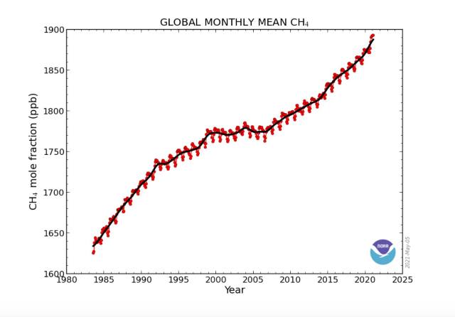
Global Methane Budget, 2000-2020
- Earth System Science Data (ESSD)
🌎
Tropomi, Mission On
Since November, 2017, the Sentinel-5 Precursor satellite has been in orbit measuring red and orange air pollution “hot spots”.
The onboard imaging spectrometer instrument, TROPOMI, tested, is measuring and monitoring methane, in particular, and ozone and other air quality-related pollutants in the atmosphere....
Oh Methane, we're watching now / Mar 26, 2018 -- https://twitter.com/CopernicusEU/status/977196577025556480
- ... #NO2 gas is very well seen on this animation made from #TROPOMI on @Sentinel5p @ESA_EO @KNMI
- Contrast between complex local #urban sources and background areas is striking with high resolution.
Tropomi
- TROPOspheric Monitoring Instrument
🌎
Speaking of Science
Environmental Defense Fund / Blog / October 2017
Detecting methane from space (from the article at EDF)
There has been quite a buzz around this unique advancement in space, and the valuable data it will provide on methane, a powerful greenhouse gas that accounts for a quarter of the warming our planet is experiencing today. Curbing anthropogenic methane emissions is one of the most efficient and economical options available to slow the rate of warming over the next few decades, while efforts continue to reduce CO2 emissions worldwide.
Methane sources include both natural and manmade emissions from livestock, agriculture, oil and gas operations, and landfills. These sources are distributed around the world and vary widely at local, regional and temporal scales—which makes it challenging to quantify emissions from diverse sources.
This is where satellites come into play. They bring together the unique capability of continuously monitoring the entire planet, measuring critical geophysical variables, and mapping change by collecting long-term datasets.
The TROPOMI satellite sensor brings significant advances in the monitoring of air pollution in terms of better resolving methane, and other major pollutants affecting air quality (e.g. NO2, SO2, formaldehyde, aerosols). For instance, data from TROPOMI will be available at 7 km x 7 km grids around the world, on a daily basis—which has never been available a this level of spatial-temporal resolution for methane or the other pollutants.
Since clouds affect the detection of methane from space, TROPOMI’s daily data coverage will be critically important to ensuring we have regular measurements of emission levels in order to build robust statistical pictures of what is happening. Combined with sophisticated techniques such as atmospheric inverse modeling, data from TROPOMI will be used to derive methane emissions occurring on the ground.
So-called “bottom-up” methods of characterizing emissions—measuring from facilities on the ground—provide valuable and detailed information about emission sources. But the bottom-up emissions inventory often has gaps. For technical, political and proprietary reasons, accurate on-the-ground data on emissions of pollutants is not available for many parts of the planet.
Yet, atmospheric inversion allows us to produce “top-down” estimates of emissions which can be done without access to a site and much less expensively. This technique accounts for complex atmospheric transport processes in determining the emission source and magnitude. The resulting emission data is key to improving emission inventories, and helping inform effective policymaking.
○
- Atmospheric Science
- Anthropocene
- Atmosphere
- Ecology Studies
- EOS eco Operating System
- Sustainability
- Sustainability Policies
- Agriculture
- Biosphere
- Digital Citizen
- Earth360
- Earth Observations
- Earth Science
- Eco-nomics
- Education
- Environmental Full-cost Accounting
- Environmental Laws
- Environmental Security
- Environmental Security, National Security
- ESA
- Global Security
- Global Warming
- Green Best Practices
- National Security
- New Definitions of National Security
- New Space
- Planet Citizen
- Planet Scientist
- Planet Citizens, Planet Scientists
- Planet API
- Strategic Demands
- ThinBlueLayer
- Wetlands
- Whole Earth
- Climate Change
- Climate Policy
- Arctic
- Cryosphere
- Geophysics and Geochemistry
- Geophysics
- Hydrology
- Natural Resources
- Ocean Science
- Planetary Science
- Space Science and Space Physics


