Global Fishing Watch
November 2014
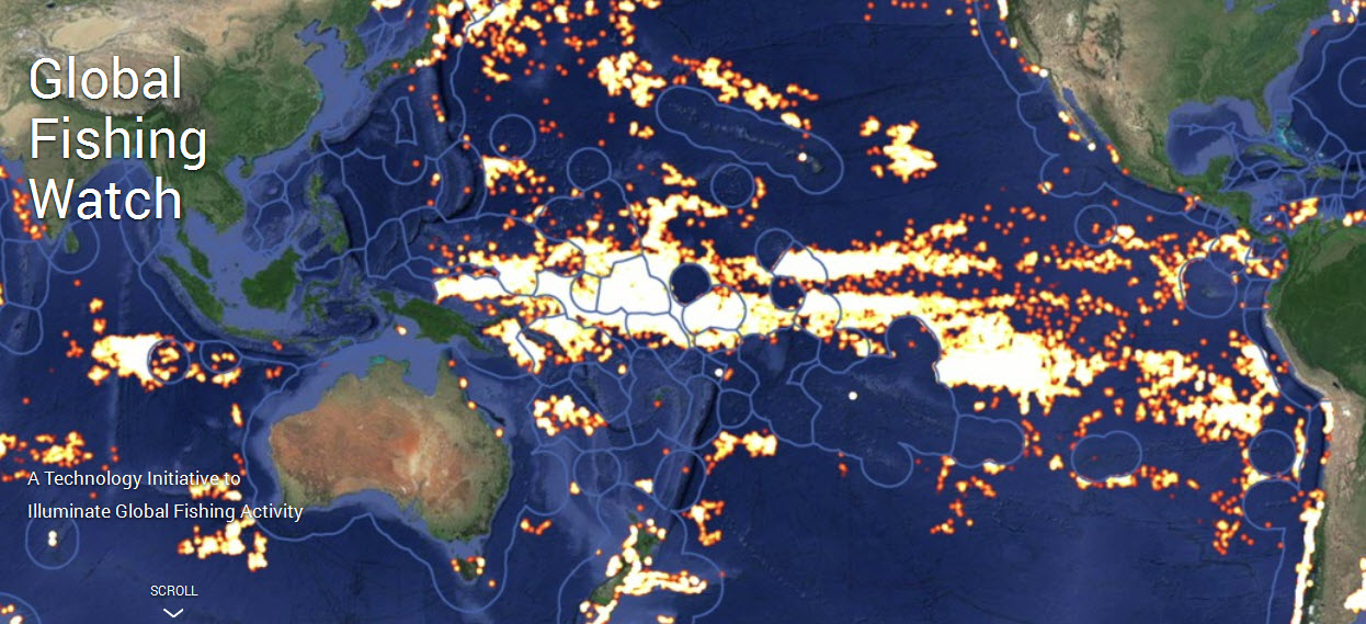
Global Fishing Watch is the product of a technology partnership between SkyTruth, Oceana, and Google Outreach that is designed to show all of the trackable fishing activity in the ocean. This interactive web tool – currently in prototype stage – is being built to enable anyone to visualize the global fishing fleet in space and time. Global Fishing Watch will reveal the intensity of fishing effort around the world, one of the stressors contributing to the precipitous decline of our fisheries.
With hundreds of millions of people around the world depending on our ocean for their livelihoods, and many more relying on the ocean for food, ensuring the long-term sustainability of our ocean is a critical global priority. We need a tool that harnesses the power of citizen engagement to hold our leaders accountable for maintaining an abundant ocean.
Global Fishing Watch will be available to the public, enabling anyone with an internet connection to monitor when and where commercial fishing is happening around the globe.
Citizens can use the tool to see for themselves whether their fisheries are being effectively managed. Seafood suppliers can keep tabs on the boats they buy fish from. Media and the public can act as watchdogs to improve the sustainable management of global fisheries. Fisherman can show that they are obeying the law and doing their part. Researchers will have access to a multi-year record of all trackable fishing activity.
The tool uses a global feed of vessel locations extracted from Automatic Identification System (AIS) tracking data collected by satellite, revealing the movement of vessels over time. The system automatically classifies the observed patterns of movement as either “fishing” or “non-fishing” activity.
This version of the Global Fishing Watch started with 3.7 billion data points, more than a terabyte of data from two years of satellite collection, covering the movements of 111,374 vessels during 2012 and 2013. We ran a behavioral classification model that we developed across this data set to identify when and where fishing behavior occurred. The prototype visualization contains 300 million AIS data points covering over 25,000 unique vessels. For the initial fishing activity map, the data is limited to 35 million detections from 3,125 vessels that we were able to independently verify were fishing vessels. Global Fishing Watch then displays fishing effort in terms of the number of hours each vessel spent engaged in fishing behavior, and puts it all on a map that anyone with a web browser will be able to explore.
○ ○ ○ ○ ○ ○ ○ ○ ○ ○ ○ ○ ○ ○ ○ ○ ○ ○ ○ ○ ○ ○ ○ ○ ○ ○ ○ ○ ○ ○ ○ ○ ○ ○ ○ ○ ○ ○ ○ ○
GreenPolicy360: Thank you Rebecca Moore for you tireless #Earth360 work
○ ○ ○ ○ ○ ○ ○ ○ ○ ○ ○ ○ ○ ○ ○ ○ ○ ○ ○ ○ ○ ○ ○ ○ ○ ○ ○ ○ ○ ○ ○ ○ ○ ○ ○ ○ ○ ○ ○ ○
Tags: Ocean; Fishing; Sustainability

