File:Ocean plant photosynthesis - measuring-monitoring via SeaWiFS.jpg: Difference between revisions
Siterunner (talk | contribs) No edit summary |
Siterunner (talk | contribs) No edit summary |
||
| Line 1: | Line 1: | ||
<big>'''''SeaWIFS full mission composite -- Monitoring decades of Ocean chlorophyll concentrations'''''</big> | |||
''Ocean Biospheres Data via NASA'' | |||
: Ocean Data | |||
• https://svs.gsfc.nasa.gov/30289 | |||
• https://svs.gsfc.nasa.gov/3938 | |||
• https://svs.gsfc.nasa.gov/cgi-bin/search.cgi?value=seawifs&expanded=filters | |||
• https://svs.gsfc.nasa.gov/30801 | |||
: Global Biosphere, Yearly Cycle | |||
• https://svs.gsfc.nasa.gov/vis/a030000/a030500/a030595/biosphere_cryo_720p.mp4 | |||
• https://svs.gsfc.nasa.gov/30595 | |||
• https://svs.gsfc.nasa.gov/11861 | |||
''The SeaWiFS instrument aboard the SeaStar satellite has been collecting ocean data since 1997. By monitoring the color of reflected light via satellite, scientists can determine how successfully plant life is photosynthesizing. A measurement of photosynthesis is essentially a measurement of successful growth, and growth means successful use of ambient carbon. This animation represents nearly a decade's worth of data taken by the SeaWiFS instrument, showing the abundance of life in the sea and along the Western seaboard of the United States. Dark blue represents warmer areas where there is little life due to lack of nutrients, and greens and reds represent cooler nutrient-rich areas. The nutrient-rich areas include coastal regions where cold water rises from the sea floor bringing nutrients along and areas at the mouths of rivers where the rivers have brought nutrients into the ocean from the land. The nutrient-rich waters contribute to some of the oxygen-poor pockets of the seas called dead zones.'' | |||
○ | |||
<big>'''Under the Earth's Surface'''</big> | |||
Life on Earth's lands and oceans and as science is beginning to discover, there is the "dark biosphere"... | |||
• https://www.sciencealert.com/scientists-lift-lid-on-massive-biosphere-of-life-hidden-under-earth-s-surface/amp | |||
○ | |||
[[Category:Climate Change]] | |||
[[Category:Earth Science]] | |||
[[Category:Global Warming]] | |||
[[Category:Green Graphics]] | |||
[[Category:Oceans]] | |||
[[Category:Planet Citizens]] | |||
[[Category:Planet Scientist]] | |||
[[Category:Planet Citizens, Planet Scientists]] | |||
[[Category:Whole Earth]] | |||
Revision as of 14:55, 15 July 2020
SeaWIFS full mission composite -- Monitoring decades of Ocean chlorophyll concentrations
Ocean Biospheres Data via NASA
- Ocean Data
• https://svs.gsfc.nasa.gov/30289
• https://svs.gsfc.nasa.gov/3938
• https://svs.gsfc.nasa.gov/cgi-bin/search.cgi?value=seawifs&expanded=filters
• https://svs.gsfc.nasa.gov/30801
- Global Biosphere, Yearly Cycle
• https://svs.gsfc.nasa.gov/vis/a030000/a030500/a030595/biosphere_cryo_720p.mp4
• https://svs.gsfc.nasa.gov/30595
• https://svs.gsfc.nasa.gov/11861
The SeaWiFS instrument aboard the SeaStar satellite has been collecting ocean data since 1997. By monitoring the color of reflected light via satellite, scientists can determine how successfully plant life is photosynthesizing. A measurement of photosynthesis is essentially a measurement of successful growth, and growth means successful use of ambient carbon. This animation represents nearly a decade's worth of data taken by the SeaWiFS instrument, showing the abundance of life in the sea and along the Western seaboard of the United States. Dark blue represents warmer areas where there is little life due to lack of nutrients, and greens and reds represent cooler nutrient-rich areas. The nutrient-rich areas include coastal regions where cold water rises from the sea floor bringing nutrients along and areas at the mouths of rivers where the rivers have brought nutrients into the ocean from the land. The nutrient-rich waters contribute to some of the oxygen-poor pockets of the seas called dead zones.
○
Under the Earth's Surface
Life on Earth's lands and oceans and as science is beginning to discover, there is the "dark biosphere"...
○
File history
Click on a date/time to view the file as it appeared at that time.
| Date/Time | Thumbnail | Dimensions | User | Comment | |
|---|---|---|---|---|---|
| current | 14:48, 15 July 2020 | 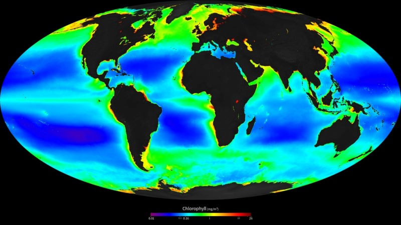 | 800 × 450 (90 KB) | Siterunner (talk | contribs) |
You cannot overwrite this file.
File usage
The following 2 pages use this file: