File:Himawari8 3WV 0200 07 JULY2015.GIF: Difference between revisions
Siterunner (talk | contribs) No edit summary |
Siterunner (talk | contribs) No edit summary |
||
| Line 5: | Line 5: | ||
Looking down at Earth from 22,000 miles out — almost three times farther than the diameter of the planet itself — allows a view of the globe as a massive organic system, pulsing with continuous movement... The satellite can see features down to about a third of a mile in size — twice the resolution of similar weather satellites that watch other parts of the globe... | Looking down at Earth from 22,000 miles out — almost three times farther than the diameter of the planet itself — allows a view of the globe as a massive organic system, pulsing with continuous movement... The satellite can see features down to about a third of a mile in size — twice the resolution of similar weather satellites that watch other parts of the globe... | ||
* http://www.jma.go.jp/jma/jma-eng/satellite/news/himawari89/20150707_himawari-8_operation_initiated.pdf | |||
* http://www.jma.go.jp/jma/indexe.html | |||
| Line 10: | Line 14: | ||
<big>'''[[Earth Right Now]]'''</big> | <big><big>'''[[Earth Right Now]]'''</big></big> | ||
* https://www.goes-r.gov/ | * https://www.goes-r.gov/ | ||
NOAA and NASA | <big>'''NOAA and NASA launch a similar advanced weather satellite, [http://www.goes-r.gov/ '''GOES-R'''], in March 2016'''</big> | ||
:'''Latest generation of geostationary weather satellites''' | |||
::'''GOES-R Series of Environmental Satellites''' | |||
'''GOES-R Series of Environmental Satellites''' | |||
''The Geostationary Operational Environmental Satellite (GOES) – R Series is the nation’s most advanced fleet of geostationary weather satellites. The GOES-R Series significantly improves the detection and observation of environmental phenomena that directly affect public safety, protection of property and our nation’s economic health and prosperity.'' | ''The Geostationary Operational Environmental Satellite (GOES) – R Series is the nation’s most advanced fleet of geostationary weather satellites. The GOES-R Series significantly improves the detection and observation of environmental phenomena that directly affect public safety, protection of property and our nation’s economic health and prosperity.'' | ||
| Line 32: | Line 32: | ||
''The GOES-R Series is a four-satellite program (GOES-R/S/T/U) that will extend the availability of the operational GOES satellite system through 2036.'' | ''The GOES-R Series is a four-satellite program (GOES-R/S/T/U) that will extend the availability of the operational GOES satellite system through 2036.'' | ||
[https://www.greenpolicy360.net/mw/images/GOES_28600286188_063130e9e4_b.jpg Whole Earth Image] | |||
[https://www.greenpolicy360.net/mw/images/GOES_28600286188_063130e9e4_b.jpg '''Whole Earth Image'''] | |||
May 2018 | May 2018 | ||
GOES-17 (GOES-S) | '''GOES-17 (GOES-S)''' | ||
* https://www.flickr.com/photos/noaasatellites/sets/72157689517218580 | * https://www.flickr.com/photos/noaasatellites/sets/72157689517218580 | ||
Revision as of 21:38, 5 May 2022
Japan’s New Earth Satellite Captures an Image of Earth Every 10 Minutes
Looking down at Earth from 22,000 miles out — almost three times farther than the diameter of the planet itself — allows a view of the globe as a massive organic system, pulsing with continuous movement... The satellite can see features down to about a third of a mile in size — twice the resolution of similar weather satellites that watch other parts of the globe...
🌎
NOAA and NASA launch a similar advanced weather satellite, GOES-R, in March 2016
- Latest generation of geostationary weather satellites
- GOES-R Series of Environmental Satellites
The Geostationary Operational Environmental Satellite (GOES) – R Series is the nation’s most advanced fleet of geostationary weather satellites. The GOES-R Series significantly improves the detection and observation of environmental phenomena that directly affect public safety, protection of property and our nation’s economic health and prosperity.
The satellites provide advanced imaging with increased spatial resolution and faster coverage for more accurate forecasts, real-time mapping of lightning activity, and improved monitoring of solar activity and space weather.
The GOES-R Series is a four-satellite program (GOES-R/S/T/U) that will extend the availability of the operational GOES satellite system through 2036.
May 2018
GOES-17 (GOES-S)
First Full Disk ABI Image from GOES-17
https://www.greenpolicy360.net/mw/images/GOES_28600286188_063130e9e4_b.jpg
File history
Click on a date/time to view the file as it appeared at that time.
| Date/Time | Thumbnail | Dimensions | User | Comment | |
|---|---|---|---|---|---|
| current | 16:40, 11 July 2015 | 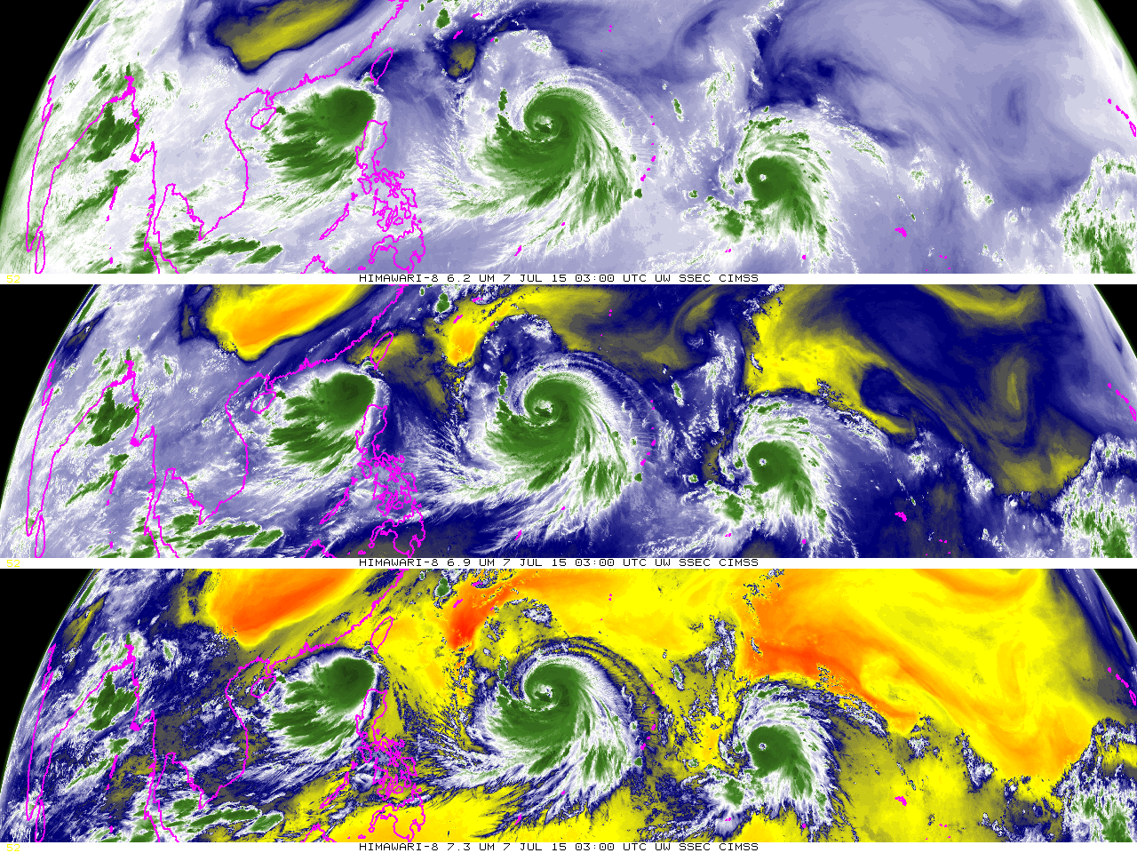 | 1,280 × 960 (616 KB) | Siterunner (talk | contribs) | Himawari-8 launched -- July 2015 [http://www.nytimes.com/interactive/2015/07/10/science/An-Image-of-Earth-Every-Ten-Minutes.html <big>'''Japan’s New Earth Satellite Captures an Image of Earth Every 10 Minutes'''</big>] Looking down at Earth from 22... |
You cannot overwrite this file.
File usage
The following page uses this file: