File:USGS Groundwater depletion map 2013.png
USGS_Groundwater_depletion_map_2013.png (794 × 490 pixels, file size: 238 KB, MIME type: image/png)
http://www.reuters.com/article/us-usa-water-idUSBRE94J0Y920130520
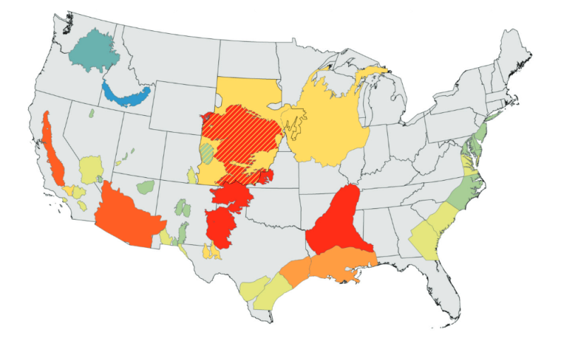
Water levels in U.S. aquifers, the vast underground storage areas tapped for agriculture, energy and human consumption, between 2000 and 2008 dropped at a rate that was almost three times as great as any time during the 20th century, U.S. officials say.
The accelerated decline in the subterranean reservoirs is due to a combination of factors, most of them linked to rising population in the United States, according to Leonard Konikow, a research hydrologist at the U.S. Geological Survey.
The big rise in water use started in 1950, at the time of an economic boom and the spread of U.S. suburbs. However, the steep increase in water use and the drop in groundwater levels that followed World War 2 were eclipsed by the changes during the first years of the 21st century, the study showed...
_____________________________________________
Ogallala Aquifer, the American 'Heartland'
http://www.croplife.com/management/stewardship/ogallala-aquifer-at-risk/
Because of widespread irrigation, farming accounts for 94% of groundwater use of the Ogallala. Irrigated ag forms the base of the multi-state economy, actually supporting nearly one-fifth of the wheat, corn, cotton, and cattle produced in the U.S.
○
- http://research.msu.edu/tag/ogallala-aquifer/
- http://research.msu.edu/saving-the-great-plains-water-supply-2/
- Large areas of the Ogallala Aquifer, one of the most important sources of water for agricultural crops in the United States, are at risk of drying up if the aquifer continues to be drained at its current rate.
- The Ogallala, also known as the High Plains Aquifer (HPA), spans from Texas to South Dakota and provides water to grow $35 billion in crops each year. However, since the 1950s, when high-volume pumping began, the HPA’s saturated volume has declined by roughly the volume of Lake Erie...
○
According to the U.S. Geological Survey, water levels across most of the Ogallala have fallen at least five feet since farmers began irrigating the Great Plains in the 1940s. Almost one-fifth of the area has dropped at least 25 feet, while 11% has lost 50 feet or more.
__________________________________________________

Earth's Future
Journal - Launched 2013 / Creative Commons Open-Access / http://onlinelibrary.wiley.com/doi/10.1002/2013EF000107/full
The future of agriculture over the Ogallala Aquifer: Solutions to grow crops more efficiently with limited water
Abstract
We explore the unsustainable path that the Ogallala region faces, and provide some suggestions for policies that would extend the usable lifespan of the water in the aquifer, which supports the vast majority of the economy across this region. We emphasize the critical role of science as a foundation for policies that can help mitigate the disaster that is occurring across the region and provide insights because we believe that there are solutions to some aspects of this water crisis.
The Ogallala Aquifer is one of the largest water bodies in the United States. Large portions of the Ogallala-High Plains Aquifer (HPA), underlying approximately 450,000 km2 of farm and range land stretching from Texas to South Dakota, are experiencing fundamentally unsustainable groundwater withdrawals due to large-scale irrigation. In some areas of Kansas and Texas, farmers can no longer pump sufficient water to meet crop demand due to aquifer depletion. If current withdrawal rates continue, such depletion will expand across extensive portions of the central and southern HPA during the next few decades.
The HPA provides water to grow more than $35 billion in crops each year. The region is dominated by agriculture (41%) and rangeland (56%), by virtue of productive soils and what was once thought to be an essentially inexhaustible water supply. However, since the 1950s, when high-volume pumping began, the HPA's saturated volume has declined by approximately 500 km3—roughly the volume of Lake Erie. Despite widespread rapid decline of the water table, which has depleted portions of the aquifer, irrigated acreage continues to expand (National Agricultural Statistics Service, Ag Census 2007 Quick Stats Tool, 2007, http://quickstats.nass.usda.gov). The expansion in water demand is being exacerbated by policies in the current Farm Bill that reward and even mandate growth in biofuels. These policy-backed incentives have contributed to higher corn prices [Pingali et al., 2008], spurring many farmers across the HPA to grow irrigated corn every year in a monoculture.
Agriculture could be sustainable across much of the HPA if crops are chosen for water requirements rather than for economic returns. However, farmers make crop selections based on a complex array of factors, driven primarily by economics. In this article, we address how broader adoption of research technologies such as crop modeling and precision agriculture can help identify best management practices to move this region toward sustainability given the current cropping systems, and advocate for policies that reward farmers for adopting soil and water conservation strategies.
Average groundwater recharge rates are highly variable across the region, with historical predevelopment estimates of less than 1 mm/yr in parts of Texas to more than 150 mm/yr in the Sandhills of Nebraska. This is driven by a strong climate gradient across the HPA with nearly three times the precipitation in the east relative to the west, and average temperatures that are 13°C warmer in the south, which results in much higher potential evapotranspiration rates. The total pumping for irrigation from the HPA exceeds estimates of average recharge by a factor of 2–7; thus, most of the region is clearly on an unsustainable path.
An exceptional drought began in the southern HPA in 2011, and since 2012 has spread across the region bringing issues of water management to the forefront. Although this recent drought has had significant impacts, it does not yet compare to the devastating and much longer droughts of the Dust Bowl or the 1950s. In the depths of the Dust Bowl, major shifts in land management began to be implemented by farmers, guided and incentivized by the newly formed Soil Conservation Service of the USDA (U.S. Department of Agriculture, Washington, D. C.). In the 1950s the region started to be less sensitive to droughts due to widespread use of irrigation from the underlying aquifer. A silver lining to the damage caused by the current drought would be to raise water management to the same level as soil management, and rather than simply having county offices focused on soil conservation, the USDA could expand their role to include water management assistance.
Climate change is expected to bring warmer temperatures and exacerbate existing precipitation and evapotranspiration gradients, increasing aridity in the southwest and humidity in the northeast [Intergovernmental Panel on Climate Change, 2007; Karl et al., 2009]. Despite the fertilization effects of increasing CO2 concentration in the atmosphere, the projected temperature increase will ultimately cause yield declines owing to faster crop development, allowing less time for biomass accumulation. New drought-resistant cultivars are being developed to increase yields, but they will likely not give higher yield during optimal or wet years. In addition, drought-resistant cultivars do not reduce the demand for water by corn, but simply increase the likelihood of a small percentage increase in yield during dry years. Thus, it is a clear misperception that these cultivars will solve water limitation issues. Recent papers have suggested a drastic rethinking of agricultural strategies [Fedoroff et al., 2010], underscoring the importance of new cultivars through molecular breeding. Although this may be a valid path, genetics alone will not be sufficient, because the yield is a result of interaction among genetics × environment × management.
One of the main impediments to water conservation is the current policy associated with federal crop insurance. Such insurance currently requires a crop to be managed as either fully irrigated or as dryland. Full irrigation insurance mandates a certain amount of water application over the growing season, disallowing deficit irrigation approaches that could save significant amounts of water. The governor of Kansas recently asked the USDA to add a limited irrigation crop insurance option, and signed a law establishing Local Enhanced Management Areas (LEMAs) under which locally generated water plans with mandatory water-use reductions can be put forward to the State Engineer for approval.
One of the primary goals of water management for agriculture is to increase the amount of crop produced per drop of water. Clear evidence exists of improved transpiration efficiency (yield per unit of transpired water) over time for irrigated crops [Basso and Ritchie, 2012]. Opportunities for further enhancement largely involve decreasing soil water evaporation relative to plant transpiration using improved irrigation systems and new agronomic practices (e.g., variable rate irrigation). Planting crops with higher plant density increases yield and decreases soil water evaporation in favor of plant transpiration [Ritchie and Basso, 2008]. The efficiency of irrigation technologies has dramatically improved in recent years, moving from early spray systems that could lose as much as 30% of the water before it hits the ground, to recent drop-pipe systems that spray water below the canopy and lose almost none. Yet even efficient irrigation systems must be operated carefully, as excess water drains through the root zone thereby leaching nutrients from the soil, demanding additional fertilizer use, and impacting water quality in the recharged aquifer below...
The current unsustainable water management strategies of the HPA and other similar regions call for a paradigm shift. In these regions, water-use efficiency and farmer's profitability can be significantly enhanced by adopting site-specific management identified by coupling precision agricultural technologies with crop models [Basso and Ritchie, 2012]. Such models can also quantify the value of different management strategies including implementing water-saving technologies such as conservation tillage, optimizing rotations, planting dates, and potential new cultivars over space and time. These approaches would keep crop yields from plummeting in water-limited environments such as the HPA, but policies solidly grounded in science are critical to ensure long-term sustainability and environmental integrity for future generations.
__________________________________________________
http://pubs.usgs.gov/sir/2013/5079/SIR2013-5079.pdf
1900-2008
Groundwater Depletion in the United States (1900−2008)
- By Leonard F. Konikow / USGS
Abstract
A natural consequence of groundwater withdrawals is the removal of water from subsurface storage, but the overall rates and magnitude of groundwater depletion in the United States are not well characterized.
This study evaluates long-term cumulative depletion volumes in 40 separate aquifers or areas and one land use category in the United States, bringing together information from the literature and from new analyses. Depletion is directly calculated using calibrated groundwater models, analytical approaches, or volumetric budget analyses for multiple aquifer systems. Estimated groundwater depletion in the United States during 1900–2008 totals approximately 1,000 cubic kilometers (km3).
Furthermore, the rate of groundwater depletion has increased markedly since about 1950, with maximum rates occurring during the most recent period (2000–2008) when the depletion rate averaged almost 25 km3 per year (compared to 9.2 km3 per year averaged over the 1900–2008 timeframe).
File history
Click on a date/time to view the file as it appeared at that time.
| Date/Time | Thumbnail | Dimensions | User | Comment | |
|---|---|---|---|---|---|
| current | 16:59, 28 May 2016 | | 794 × 490 (238 KB) | Siterunner (talk | contribs) |
You cannot overwrite this file.
File usage
The following page uses this file:
- Aquifers
- Citizen Science
- Climate Change
- Desertification
- Earth360
- Earth Observations
- Earth Science
- Earth Science from Space
- Environmental Full-cost Accounting
- Environmental Security
- Environmental Security, National Security
- EOS eco Operating System
- Geophysics and Geochemistry
- Geology
- Geophysics
- Hydrology
- Natural Resources
- Permaculture
- Planet API
- Planet Citizen
- Planet Scientist
- Planet Citizens, Planet Scientists
- Planetary Science
- Sustainability
- Sustainability Policies
- Virtual Earth
- Virtual Planet
- Water
- Water Saving
- Wetlands
- Whole Earth