File:Multispectral Scanning Systen - MSS.jpg
Multispectral_Scanning_Systen_-_MSS.jpg (688 × 587 pixels, file size: 103 KB, MIME type: image/jpeg)
NASA-NOAA 'Multispectral' Earth Science, Digital and Dynamic
Over Five Decades of Unique Earth Science Imaging from Space
- A Profoundly Vital Resource of Digital Data Mapping Earth's Systems
- Beginning with the Work of 'the MSS', the Multispectral Scanning System

Beginnings of the Modern Environmental Movement

The Earth Observing System (EOS)
The mission of the Earth Observing System that became a core element of the ongoing NASA earth science programs was first envisioned in the 1970s. The constellation of satellites that now comprise a connected matrix of ongoing earth imaging programs (see the latest here) came about as the U.S.
Congress realized in the years following NASA's establishment that Planet Earth was central to NASA's work. The initial NASA mission statement spoke of this study of Planet Earth as a key goal of NASA programs. A new science, space and technology Congressional Committee was created to envision and oversee these programs and one of the first realizations about the need for earth science came about through the LANDSAT program (see here). A historic moment brought into existence digital mapping, that is, multi-spectral imaging of earth from an orbiting satellite in space, envisioned and designed to collect and 'save' data of earth's living systems. This databank was considered to be essential by committee member George E. Brown who, as a physicist and engineer, began his three-decade + career in Congress. George eventually became known for his "big science" initiatives. What few knew back then at the beginning was how essential this data would become as climate science came into the light (in 1977 and '78 with George's work central to the drafting and passage of the first National Climate Act.)
George E. Brown was a special person who brought a physics and engineering background to Congress. George saw what others didn't really understand. Your GreenPolicy360 siterunner began to realize the future to come when he showed me the Mission Statement of NASA. -- “To understand and protect our home planet..."
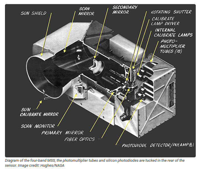
The Multispectral Scanning System
Virginia Tower Norwood decided to quantize the MSS data into 6-bits. Both image data and calibration data (from the onboard internal lamp calibrator) were sent to the ground digitally. Even though the digital MSS data had a small dynamic range (able to show only 64 different radiance values), it could be calibrated, so images could be confidently compared from date-to-date and place-to-place.
The MSS radiometrically-corrected digital data pioneered quantitative satellite remote sensing, taking the science of Earth observation digital, where it has stayed ever since...
Read Virginia's story -- https://www.greenpolicy360.net/w/LANDSAT_and_Virginia_Tower_Norwood
Read George's story -- https://www.greenpolicy360.net/w/George_E._Brown_Jr
Planet Citizens, Landsat Visionaries - George E. Brown & Virginia Tower Norwood

50th + Anniversary of Landsat

http://www.greenpolicy360.net/mw/images/Landsat8DataUsersHandbook.pdf
Envisioned as an Intergenerational Science Mission
The first land-focused Earth-observation satellite, Landsat 1 (initially called the 'Earth Resources Technology Satellite-1 / ERTS-1) is launched to Earth orbit from Vandenberg, CA.
Beginnings of Earth Science from Space #RemoteSensing #AtmosphericScience #EarthScience #OceanScience


File history
Click on a date/time to view the file as it appeared at that time.
| Date/Time | Thumbnail | Dimensions | User | Comment | |
|---|---|---|---|---|---|
| current | 18:19, 20 September 2022 | | 688 × 587 (103 KB) | Siterunner (talk | contribs) |
You cannot overwrite this file.
File usage
- Atmosphere
- Atmospheric Science
- Biodiversity
- Citizen Science
- Clean Air
- Clean Water
- Climate Change
- Climate Policy
- Earth
- Earth360
- EarthPOV
- Earth Day
- Earth Imaging
- Earth Observations
- Earth Science
- Earth Science from Space
- Earth System Science
- Eco-nomics
- Ecological Economics
- Ecology Studies
- Environmental Laws
- Environmental Protection
- Environmental Security
- Environmental Security, National Security
- EOS eco Operating System
- Global Security
- Global Warming
- GreenPolicy360
- Green Graphics
- Land Use
- Maps
- NASA
- New Definitions of National Security
- NOAA
- Oceans
- Planet Citizen
- Planet Citizens
- Planet Citizens, Planet Scientists
- Pollution
- Resilience
- Rivers
- Strategic Demands
- Sustainability
- Sustainability Policies
- Toxics and Pollution
- US Environmental Protection Agency
- Water Quality
- Whole Earth