File:Landsat launched 50 years ago today.png
Original file (528 × 779 pixels, file size: 755 KB, MIME type: image/png)
July 23, 2022
NASA Landsat Program
- Landsat launched 50 years ago today in July 1972
GreenPolicy360 and Siterunner Steve Schmidt are celebrating....
Let's look back and remember a generational program of #EarthScience starting up, thriving then being threatened, surviving and now continuing to deliver open access and unique whole earth data for 50+ years.
Here are some thoughts today as we continue on with the mission...
🌎
NASA Landsat Program @NASA_Landsat
We're celebrating a half century of #Landsat today!
It was #OTD in 1972 that Landsat 1 launched. If you want an in-depth history of the #Landsat Program, this ~600-page #OpenAccess book is for you!
Landsat's Enduring Legacy (published in 2017): https://my.asprs.org/landsat
GO NASA #Earth Science
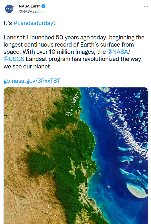
Landsat 1 launched 50 years ago today, beginning the longest continuous record of Earth’s surface from space. With over 10 million images, the @NASA/@USGS Landsat program has revolutionized the way we see our planet.
Since its debut, Landsat has amassed over 10 million images. These images, also called scenes, show current snapshots of land and coasts, but pair with images of years past and they also reveal changes through time – glaciers slowly disappearing, or urban spaces sprawling across the landscape.
These scenes and time series have myriad applications around the globe: Hydrologists use them to track how rivers change; ecologists use them to determine the extent of deforestation; farmers and agricultural organizations use them to analyze crop health...
Happy Golden Anniversary, Landsat!
Fifty years later, we cannot thank you enough. Landsat has revolutionized how we study geography, agriculture, human health, and extreme weather (just to name a few). Read about how Landsat impacts your life here: http://ow.ly/ZylH50K2qbM
Tanya Trujillo @AsstSecTrujillo
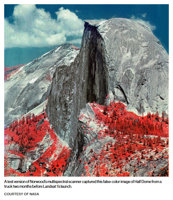
In celebration of #Landsaturday, check out this cool video about Virginia Norwood, the mother of Landsat, and the Little Scanner That Could. #Landsat50 #WomeninSTEM @USGSLandsat
@LadiesOfLandsat
@NASAEarth
NASA Landsat Program Retweeted
NASA Goddard @NASAGoddard
On July 23, 1972, NASA launched the Earth Resources Technology Satellite, the first satellite of what became the @USGS / @NASA_Landsat Program.
As we celebrate Landsat's 50th birthday this weekend, join us in a look back here: https://go.nasa.gov/3z2MXEx
🌎
NASA Landsat Program Retweeted
NASA History Office @NASAhistory
A 50-year legacy of how we visualize change on Earth started today!
When Landsat 1 was launched into orbit on July 21, 1972, few would have predicted it would become part of the longest running Earth-imaging satellite program. @NASA_Landsat @USGSLandsat
Steven Schmidt @mchanneling quoted/retweeted
Rep. George E Brown predicted #Landsat would greatly advance #EarthScience. He supported & protected the Landsat mission for 3 decades. He saw the Earth imaging database as digital gold, 'measuring, monitoring to manage'... it's a profound legacy
July 23, 2022

○

GreenPolicy360: Memories from the late 60s/early 70s:
Steve Schmidt / GreenPolicy360's founder: I was fortunate, beginning in the 1960s, to listen to Congressman Brown Congressman George E. Brown point to the NASA plan and explain how he saw Congress put into action the reality of a multi-year, coordinated, multi-agency program to achieve mission goals. Earth science, measuring and monitoring Earth's life-enabling systems was given highest priority. Landsat's program was set in motion as a decades long, first-ever digital scanning remote satellites data collecting study. An array of satellites began to launch, creating and combining the expanding resources of NASA, USGS, NOAA, and an array of educational and scientific institutions and aeronautics business.
The overall goal, Representative Brown would continue to explain in his Congressional Science, Space & Technology leadership roles over the decades, was to understand, preserve and protect our planet as we, humanity, develop the science to look beyond the Earth and study 'the heavens'.
Here's to George Brown and the many visionaries, thinkers and doers who have carried on preserving and protecting our home planet.
~
When Congressman Brown drafted originating legislation establishing a national climate change research program via the National Climate Program Act of 1978, the scientific community and nation were just beginning to awaken to a new national security threat. I remember his concern, our concern. He was trained as a scientist, an engineer, with an ability to see facts and data sets in a way others could not.
Representative Brown was out in front of "Big Science". In his decades on the House Science, Space & Technology Committee, he worked to expand the reach of science. He knew that good data enabled good policy decisions. He pressed for first-generation earth science satellites and ongoing earth monitoring missions and data sharing.
Among his many initiatives, George Brown was a key figure in proposing, establishing, and then saving the Landsat program and its unique 'open-access' database of Earth Science imaging when President Reagan attempted to shut Landsat down. Landsat was a model for all the following earth science research missions from space and is now moving into its fifth decade with Landsat 9.
🌎
Earth Science Research from Space
- Landsat and Virginia Tower Norwood
A Story of the Genius of Virginia Tower Norwood & Launch of Landsat's Earth Science Mission
GreenPolicy360 Siterunner: The U.S. Interior Department, the U.S. Geological Survey, NASA with the Congressional Science and Technology Committee (originally the Science and Astronautics Committee were responsible for building the original Landsat program (which overcame much opposition within the military). ERTS-1, the Earth Resources Technology Satellite, as the original Landsat satellite was officially first called, was 'greenlighted' to go as a real time earth observation mission in 1970. The vast digital database it gathered has proven over the years the wisdom of the visionaries who first proposed, drafted legislation creating, funding, then engineering, testing, launching and ably defending the Landsat mission from critics over the decades. Now the results are being re-considered for the unique value they provide in guiding policy discussion, debate and decisions. The Landsat library of imagery, millions of images, multispectrum observations of change on earth over the first fifty years of the mission's existence, are seen in a new light.
Earth/Space Science, Landsat Update: April 2021
SJS/GreenPolicy360 Siterunner:
A tip of our GreenPolicy360 hat to George E. Brown Jr who envisioned the Landsat's mission, the beginning of earth imaging and open access to the data and as a science leader in the US Congress supported, expanded and protected the earth science mission over the decades. The launch now, in April 2021, of Timelapse by Google Earth realizes a next step in George's decades-long quest to bring knowledge of our home planet to all citizens.

Rebecca Moore: "This work was possible because of the U.S. government and European Union’s commitments to open and accessible data. Not to mention their herculean efforts to launch rockets, rovers, satellites and astronauts into space in the spirit of knowledge and exploration. Timelapse in Google Earth simply wouldn’t have been possible without NASA and the United States Geological Survey’s Landsat program, the world’s first (and longest-running) civilian Earth observation program, and the European Union’s Copernicus program with its Sentinel satellites."
Timelapse from Google Earth
Welcome to Timelapse!
Rebecca Moore, Director, Google Earth, Earth Engine & Outreach:
To explore Timelapse in Google Earth, go to g.co/Timelapse — choose any place on the planet where you want to see time in motion.
Launch Date: April 15, 2021

🌎
Thirty plus years setting the agenda for visionary science in the House of Representatives
Rep. George E. Brown, an activist member and for many years chair of the House Committee on Science, Space, and Technology
At the beginning of the 'space race', the House Committee on Science and Aeronautics was created by the 85th Congress in 1957 to oversee the newly-created National Aeronautics and Space Administration (NASA). The Science and Aeronautics Committee was the first committee since 1892 to be established for an entirely new area of jurisdiction. The committee’s jurisdiction over the years has expanded to include most civilian non-medical scientific research throughout the government, including National space policy, Earth remote sensing policy; Space commercialization, including commercial space activities relating to the Department of Transportation and the Department of Commerce, the National Science Foundation, the Energy Department, the National Institute of Standards and Technology (NIST), EPA, NOAA and the Department of Homeland Security. (Informally known as the Science committee, the committee's name was change to the "Committee on Science and Technology" in 1974. At that time, the Committee’s jurisdiction was expanded to include legislation related to energy, the environment, the atmosphere, civil aviation research and development, and the National Weather Service. The Committee on Science and Technology was also given a "special oversight" function providing for exclusive responsibility among all Congressional Standing Committees to review and study, on a continuing basis, all laws, programs and government activities involving Federal non-military research and development. In its early years, the Committee was an important partner in the Apollo Program that led to a man landing on the moon and strengthening science education and scientific research. After the Committee’s role expanded, the Committee has played an important role in much of the legislation Congress has considered dealing with domestic and international science, technology, standards, and competitiveness. In the 112th Congress, Chairman Hall changed the Committee's name to the "Committee on Science, Space and Technology."
○ ○ ○ ○ ○ ○ ○ ○ ○ ○ ○ ○ ○ ○ ○ ○ ○ ○ ○
Via Wikipedia / https://en.wikipedia.org/wiki/George_Brown_Jr.
Brown was known as a champion for science. He left behind a deep and expansive legacy that has shaped science and science policy in America. Among some of his many accomplishments during his service on the House Science Committee:
• Established the first federal climate change research program in the Federal Climate Program Act of 1978
• Established the Office of Science and Technology Policy
• Established the Environmental Protection Agency
• Established the Office of Technology Assessment
Rep. George Brown brought his extensive work with U.S. top scientists, featured in the work of 1977's Energy and Climate Report of the National Academy of Sciences and follow on 1979 Academy Climate Science report that was presciently accurate in its predictions.
The Congressman-Engineer emphasized, constantly to me and in his work, the essential importance of having accurate data in order to make the best possible engineering decisions. He imprinted, if I could use this word to its fullest meaning, the vital nature of gathering information with studies over time to monitor changes. He was in a position, one of the most powerful positions in government, to shape the policies of science -- atmospheric science, earth science, big science.
Whenever we see the NASA 'marching directive' "You can manage only what you can measure", think of George. The original mission statement of our nation's first ventures into space began with studying the home planet. Measuring and monitoring became a mantra of Earth Science...

The Congressman left us a legacy of vision and action against threats to the atmosphere, earth's life systems, and sustainability.
We have, all who believe in the importance of science, carried forward his thoughts over the years since the 1960s and 1970s. As best we could, we have carried on against deep odds and opposition by those with other goals.
The Original Mission Statement of NASA ((1958) provided Congressional intent and guidance to the first generation of space programs. George, if he were here, would've done I am certain everything within his power to protect the original mission statement...
🌎
Over the years, three decades, Congressman Brown continued supporting and protecting the Landsat mission...
George Brown's political action saved the Landsat program.
A 'Near Ending' of the Landsat program
President Reagan moves to cancel Landsat, George Brown acts to continue Landsat
Congressman George Brown's political action saved the Landsat program. The Congressman out in front of "big science" for decades was a key figure in the Landsat program, the long-running database of imagery of Earth that is moving on to its fifth decade with Landsat 9 (and open access) as a result of Brown's efforts. On the House science committee for over 30 years, George led an array of science efforts, including one that greens look to as prescient -- he drafted legislation establishing the first national climate change research program via the National Climate Program Act of 1978. Congressman Brown, from 1964 until his untimely passing in 1999, was a mentor for your GreenPolicy Siterunner.

NASA: Earth Sciences
Landsat 9 propels the program past 50 years of collecting global land cover data
Landsat 9 was successfully launched on Monday, Sept. 27, 2021 from Vandenberg Space Force Base in California. Landsat 9 data is publicly available from USGS.
Landsat 9 — a partnership between NASA and the U.S. Geological Survey— continues the Landsat program’s critical role in monitoring, understanding and managing the land resources needed to sustain human life.
Landsat 9 continues to provide a critical, one-of-a-kind, long-running database of #EarthScience imagery of the home planet and life-support systems
○

🌎
File history
Click on a date/time to view the file as it appeared at that time.
| Date/Time | Thumbnail | Dimensions | User | Comment | |
|---|---|---|---|---|---|
| current | 20:38, 23 July 2022 | | 528 × 779 (755 KB) | Siterunner (talk | contribs) |
You cannot overwrite this file.
File usage
The following 10 pages use this file:
- George E. Brown Jr
- Google Earth
- File:Earth Observing System - fleet of satellites.png
- File:Global Stocktake, the first GST.jpg
- File:How satellites monitor climate change circa 2016.png
- File:Landsat, a 50 year legacy.png
- File:Landsat 50th anniv Sept 2016.jpg
- File:Methods to enforce climate pledges-NDCs - Dec 2021.png
- File:Monitoring Greenhouse Gases from Satellite Missions 2021-2030.png
- File:Rebecca Google Outreach.jpg
- Maps
- Agricultural Economics
- Agriculture
- Democratization of Space
- Earth360
- EarthPOV
- Earth Art
- Earth Observations
- Earth Science
- Earth Science from Space
- Environmental Protection
- Global Security
- Green Graphics
- Green Politics
- Land Use
- NASA
- New Space
- Planet API
- Planet Citizen
- Planet Citizens, Planet Scientists
- Space Science and Space Physics
- Whole Earth
- Alternative Agriculture
- Aquifers
- Appropriate Technology
- Biodiversity
- Bioneers
- Biogeosciences
- Bioregionalism
- Eco-nomics
- Ecology Studies
- Ecoregions
- EOS eco Operating System
- Farm-Related Policies
- Food
- Food-Related Policies
- Green Best Practices
- Land Ethic
- Permaculture
- Resilience
- Soil
- Strategic Demands
- Sustainability
- Sustainability Policies
- Water
- Watersheds
- Wetlands
- Atmospheric Science
- Climate Change
- Climate Policy
- Planetary Science