File:DSCOVR-EPIC 187 1003705 m americas dxm.png
DSCOVR-EPIC_187_1003705_m_americas_dxm.png (502 × 502 pixels, file size: 330 KB, MIME type: image/png)
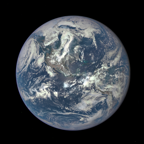
July 21, 2015 / An EPIC New View of Earth
First Images: "The high quality of the EPIC images exceeded all of our expectations in resolution... There will be a huge wealth of new data for scientists to explore."
Looking @Earth from the DSCOVR-EPIC satellite mission: --- Adam Szabo, DSCOVR project scientist, NASA’s Goddard Space Flight Center in Greenbelt, Maryland
Daily DSCOVR - EPIC Images:
https://x.com/dscovr_epic?s=11&t=14LnFHA-cgLSdk-DhRp7cw
http://www.greenpolicy360.net/mw/images/DSCOVR-EPIC_187_1003705_americas_dxm.png
From a Million Miles Away, NASA Views Earth
from Andrew Revkin and Neil deGrasse Tyson
GreenPolicy: Monday, we found the message below our email in-box — sent from the White House, but penned by Tyson. It’s his reflection on the newest “Blue Marble” photograph of our home planet.
Here is Neil deGrasse Tyson’s note on arrival of the first images:
Earth.
Not mounted on a stand, with color-coded state and national boundaries, as schoolroom globes are prone to display. Instead, we see our world as only a cosmic perspective can provide: Blue Oceans — Dry Land — White Clouds — Polar Ice. A Sun-lit planet, teeming with life, framed in darkness.
In 1972, when NASA’s Apollo 17 astronauts first captured an entire hemisphere of our planet, we were treated to such a view. The Blue Marble, it was called. [Here] The Space Program’s unprecedented images of Earth compelled us all to think deeply about our dependence on nature and the fate of our civilization.
Of course, at the time, we had other distractions. Between 1968 and 1972, the United States would experience some of its most turbulent years in memory, simultaneously enduring a hot war in Southeast Asia, a Cold War with the Soviet Union, the Civil Rights Movement, campus unrest, and assassinations. Yet that’s precisely when we voyaged to the Moon, paused, looked back, and discovered Earth for the first time.
The year 1970 would celebrate the first Earth Day. In that same year, the Environmental Protection Agency (EPA) and the National Oceanic and Atmospheric Administration (NOAA) were formed with strong bipartisan support. In 1972, the pesticide DDT was banned and the Clean Water Act was passed. And one year later, the Endangered Species Act would be enacted, the catalytic converter would be introduced, and unleaded automotive emission standards would be set. A stunning admission that we’re all in this together, with a common future on a shared planet...
(We) live in a turbulent world. But we now have at our disposal, not simply a photograph of our home to reflect upon, but continual data of our rotating planet, captured 13 times per day, by the robotic Deep Space Climate Observatory (DSCOVR), a specially designed space camera & telescope, launched and positioned a million miles from Earth.
We (as "Planet Citizens") will now be able to measure and track Sun-induced space weather as well as global climactic trends in ozone levels, aerosols, vegetation, volcanic ash, and Earth reflectivity, all in high resolution; just the kind of data our civilization needs to make informed cultural, political, and scientific decisions that affect our future.
Occasions such as this offer renewed confidence that we may ultimately become responsible shepherds of our own fate, and the fate of that fragile home we call Earth.
- ○ ○ ○ ○ ○ ○ ○ ○ ○ ○ ○ ○ ○ ○ ○ ○ ○ ○
NASA's first view of the 'entire sunlit side of the Earth since Apollo 17'
http://earthobservatory.nasa.gov/IOTD/view.php?id=86257
After journey of about 1.6 million kilometers (1 million miles) to the L1 Lagrange Point, the satellite and its Earth Polychromatic Imaging Camera (EPIC) has returned its first view of the entire sunlit side of Earth. At L1—four times farther than the orbit of the Moon—the gravitational pull of the Sun and Earth cancel out, providing a stable orbit and a continuous view of Earth. The image above was made by combining information from EPIC’s red, green, and blue bands. (Bands are narrow regions of the electromagnetic spectrum to which a remote sensing instrument responds. When EPIC collects data, it takes a series of 10 images at different bands—from ultraviolet to near infrared.)
This first public image shows the effects of sunlight scattered by air molecules, giving the disk a characteristic bluish tint. The EPIC team is developing data processing techniques that will emphasize land features and remove this atmospheric effect. Once the instrument begins regular data acquisition, new images will be available every day, 12 to 36 hours after they are acquired by EPIC. These images will be posted to a dedicated web page by autumn 2015. Data from EPIC will be used to measure ozone and aerosol levels in Earth’s atmosphere, as well as cloud height, vegetation properties, and the ultraviolet reflectivity of Earth. NASA will use this data for a number of Earth science applications, including dust and volcanic ash maps of the entire planet.
It has not been possible to captures images of the entire sunlit side of Earth at once since Apollo 17 astronauts captured the iconic Blue Marble photograph in 1972. While NASA has released other blue marble images over the years, these have mostly been mosaics stitched together with image processing software—not a single view of Earth taken at one moment in time.
“This first DSCOVR image of our planet demonstrates the unique and important benefits of Earth observation from space,” said NASA Administrator Charles Bolden.
“As a former astronaut who’s been privileged to view the Earth from orbit, I want everyone to be able to see and appreciate our planet as an integrated, interacting system.”
http://www.greenpolicy360.net/w/File:Dscovr_epic_moontransit.gif

File history
Click on a date/time to view the file as it appeared at that time.
| Date/Time | Thumbnail | Dimensions | User | Comment | |
|---|---|---|---|---|---|
| current | 08:24, 27 August 2015 | | 502 × 502 (330 KB) | Siterunner (talk | contribs) | <big>'''''July 21, 2015 / An EPIC New View of Earth'''''</big> ''"The high quality of the EPIC images exceeded all of our expectations in resolution... There will be a huge wealth of new data for scientists to explore."'' ''--- Adam Szabo, DSCOVR pro... |
You cannot overwrite this file.
File usage
The following 3 pages use this file:
- Atmospheric Science
- Biosphere
- Democratization of Space
- EOS eco Operating System
- Earth360
- EarthPOV
- Earth Imaging
- Earth Observations
- Earth Science
- Earth Science from Space
- Environmental Protection
- Environmental Security
- Environmental Security, National Security
- Global Security
- NASA
- New Space
- Planet Citizen
- Planet Citizens
- Planet Citizens, Planet Scientists
- Planetary Science
- Space Science and Space Physics
- Solar Energy
- Strategic Demands
- Sustainability
- ThinBlueLayer
- Whole Earth