Benton County, OR Multi-Species Habitat Conservation Plan
Type: Policy
Status: Last Revised on 2/15/06
Source File: http://www.co.benton.or.us/parks/hcp/documents/HCPProposal.pdf
Text:
PROJECT STATEMENT
Need
Prairies and savannas once occupied over 1,700,000 acres in the western interior valleys of Oregon, Washington, and British Columbia; today less than one percent of the prairie habitats remain making them among the most endangered ecosystems in the North America. Historically, Oregon white oak woodlands were also a major component of the Willamette Valley in Oregon, landscape and today relatively few stands of oak remain, in comparison to the historic landscape. Many native species dependent on these habitats are considered critically imperiled, imperiled, or rare throughout their range. For many species, the remaining habitat is too small and too fragmented to sustain viable populations. These small fragments of grassland habitats are susceptible to loss through a variety of threats including (but not limited to): land conversion (residential/industrial development and agriculture), invasive species encroachment, succession, and roadside maintenance/spraying.
Benton County (the County) is one of seven counties in the Willamette Valley and encompasses some of the highest quality remaining prairie and oak/savanna remnants in Oregon. This planning assistance grant will allow the County to develop an HCP and expand upon current conservation efforts by increasing restoration opportunities on county and other private lands, providing long-term protection of populations and habitat, and allowing for a more economical and ecological approach to species conservation and mitigation. The County and its citizenry are committed to creating a sustainable community for present and future residents. To achieve this, the County will need to proceed with a holistic perspective toward the built and natural environment, and in a strategic, collaborative and respectful manner toward all parties involved.
By working collaboratively with stakeholders, wildlife agencies, and other local organizations the County proposes to develop a plan that provides an ecosystem approach to conservation and a process that works for both landowners and rare species. The County has the opportunity to serve as a model for other counties by establishing an efficient way to incorporate species conservation into local land use planning and facilitate economic growth and development.
The County supports an estimated 13% of the remaining prairie, savanna, and oak habitat in the Willamette Valley. These lands are home to a number of endemic Willamette Valley plants, invertebrates, and vertebrate species that are federally listed under the Endangered Species Act, considered candidate species, or species of concern.
Covered Species
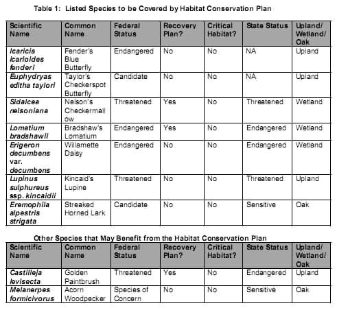
The County proposes to develop a habitat conservation plan that will provide for protection of two invertebrate species, four plant species, and one vertebrate species (See Table 1). Additionally, the implementation of the habitat conservation plan is anticipated to benefit the western gray squirrel, white breasted nuthatch, acorn woodpecker, and Oregon vesper sparrow.
Covered Activities
The County provides a variety of services to its residents, which may directly or indirectly impact and/or benefit these rare species. These services include, but are not limited to, transportation, land use regulations, parks and natural area management.
Transportation: Road construction, operations, and maintenance activities have the potential to affect these listed species and would be covered by the Habitat Conservation Plan. The County’s Public Works Department alone maintains about 190 miles of gravel roads and 270 miles of paved roads. Of particular concern for the County are populations of Fender’s blue butterfly and Kincaid’s lupine, which are known to occur along road right-of-ways.
Land Use Planning: The County’s Community Development Department’s primary objective is to ensure that development and conservation needs are balanced, and the Building and Land Use Laws of the State of Oregon and the County are followed in a fair and equitable manner. A one-stop permit service coordinates the issuance of permits for other county departments involved in development activities. By developing an HCP, the County will not only be able to more efficiently plan for future development but will also be able to incorporate federal permitting requirements into their established one-stop permit service to landowners for development activities.
Parks and Natural Areas: The County’s Natural Areas and Parks Department maintains 13 parks with a total of approximately 1,400 acres. Several of these parks not only provide camping and fishing opportunities but also support approximately 320 acres of rare oak savanna and prairie habitat that is currently managed as natural open space. The County’s natural areas include, Fort Hoskins Historic Park that supports 70 acres of prairie and savanna habitat, the 144-acre Jackson-Frazier Wetland includes 72 acres, the Beazell Memorial Forest that is being managed for 100 acres of oak savanna habitat, and the 308-acre Fitton Green Natural Area encompasses 78 acres. These natural areas currently support several rare species including many of those previously identified. Most noteworthy is that The County’s Natural Areas support one of the two known Taylor’s checkerspot populations in all of Oregon.
As evidenced by the County’s establishment of these areas, they understand the importance of strategically planning for long-term habitat conservation. This project will allow the County to enhance the established natural space reserve system to further conservation efforts for these disturbance dependent habitats. If funded, this grant will allow the County to develop a habitat conservation plan that establishes an ecosystem approach to conserving upland and wet prairies and oak savanna habitat. By strategically designing reserves that provide long-term protection to the covered species, this habitat conservation plan will allow the County to establish viable meta-populations for covered species that currently are isolated from one another and not considered viable over the long-term.
In developing the HCP with the assistance of this Title VI grant, the USFWS must ensure that the project is completed with planning forethought that considers the plan’s role in endowing future generations a sustainable environment. The National Environmental Policy Act (NEPA) provides the framework for ensuring that such holistic planning is done. The County is committed to proactively ensuring that the NEPA process will be used as a tool to comprehensively consider the public and resource conservation needs.
Goals and Objectives
As stated in their Mission Statement, Making Benton County a better place to live. Benton County Government brings to its citizenry the authority, structure and services to respond to public concerns and opportunities and provide a means for local decision-making. Developing an HCP meets the goals of the County’s mission by allowing the community to contribute to the planning process and develop a tool that allows the County and landowners to address their Endangered Species Act compliance while facilitating economic growth and development. This project has several specific goals, which are outlined below:
- Conduct public outreach to obtain input from local landowners in identifying the goals and objectives for the plan and potential conservation measures.
- Develop an ecosystem based habitat conservation plan that provides long term protection for a variety of listed plant, vertebrate, and invertebrate species.
Tasks to accomplish these goals include, but are not limited to:
- Hold a series of public meetings and educational outreach workshops
- Conduct a baseline habitat assessment/field inventory of the species to determine baseline conditions, geographic distributions, degree of habitat fragmentation, local threats, and inform planning decisions.
- Involve schools and the broader community in habitat assessment activities
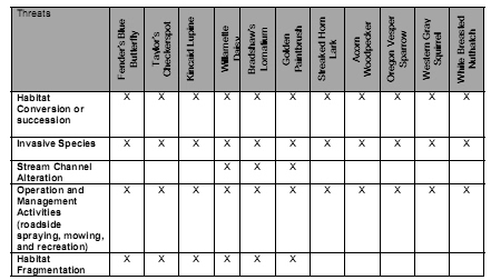
- Identify management actions to address the threats (See Table 2) and the County’s covered activities.
- Establish an efficient permitting process for private landowners for Section 10 USFWS permit (certificates of inclusion)
- Identify measures to avoid, minimize, and mitigate the affects of covered activities on the species and their habitat.
- Increase opportunities for landowners interested in conservation
- Develop management criteria for reserve lands
Table 2: Threats to Listed Species Subject to Habitat Conservation Plan

Expected Results or Benefits
The habitat conservation plan will serve as a landscape-level planning tool. Focus will be on conserving the remaining upland/wet prairie and oak savanna habitats in the County as is feasible through the establishment of a network of reserves for which a comprehensive management plan will be prepared. Economic growth and land use planning will be allowed to continue without jeopardizing these listed plant and animal species.
General benefits for all of the species may include management actions that provide for the preservation of habitat through acquisition in fee-simple or conservation easements; habitat enhancement or restoration of degraded or former habitat; creation of new habitat (last resort); establishment of buffers around existing habitat; modification of land use practices; and public information and education programs. Management actions may also include development of a species conservation bank. The management plan for the reserve lands will identify how these disturbance-dependent habitats will be maintained to benefit the covered species.
Major species-specific benefits include:
- The County upland prairies support all of the known Taylor’s checkerspot butterfly populations for the state of Oregon. There are only six extant populations in Washington, and the species has been extirpated from British Columbia. By developing this HCP the County and community can make a significant contribution to the permanent conservation of this species throughout a significant portion of its current range.
- The current range of the Fender’s blue butterfly extends across four counties in the Willamette Valley with Benton County supporting several of the largest remaining populations. This project will contribute to the long-term conservation of this species with the goal of establishing a functioning metapopulation instead of the current conditions where habitat patches across the range are isolated from one another and the populations are not viable over the long-term. In addition, conditions for the threatened Kincaid’s lupine, host plant for Fender’s blue butterfly, will also be improved.
- Implementation of the management activities identified in the Habitat Conservation Plan may prevent future species listings under the Endangered Species Act, specifically the oak dependent species that are currently species of concern.
- Although not one of the covered species, the Golden paint brush is the plant species likely to benefit the most from this project because it is currently believed to be extirpated from Oregon. Studies are currently being conducted to determine appropriate measures for restoring populations in the Willamette Valley. This project will identify sites that will be permanently conserved and can be used to re-establish golden paintbrush populations in Oregon.
Within the Willamette Valley, significant portions of these habitats are located on private lands and the threat of loss of habitat for these species is significant. The development of a habitat conservation plan will assist in reducing potential land use conflicts that can be associated with economic growth and development and species conservation. The habitat conservation plan will cover activities occurring within the County that have the potential to affect the seven species to be covered by the plan and provide benefit for additional species. This project will assist the County with Endangered Species Act compliance for activities performed during the regular course of its business, such as management actions and maintenance activities, regulating activities, and permitting projects. The plan will provide a mechanism for landowners to off-set unavoidable impacts to species making the permitting process more efficient and timely.
The project will allow the County and its citizens to develop conservation partnerships that provide real benefits to endangered species and their community, and ensures that decision-making for endangered species is made at the local level. This project also provides certainty for the County and landowners by providing assurances that no additional conservation measures will be required in the future.
Based on the baseline survey report, the County will have a good understanding of the status of the listed species on public lands within the county, as well as on the lands of private landowners willing to allow such surveys to occur. The County will conduct public outreach efforts to include both local entities and private landowners in the Habitat Conservation Plan. The effort will outline the benefits of be part of the HCP process, including implementation.
This planning effort will be completed for all prairie and oak savanna habitat in the County. If funded, this project may be the first County HCP to be completed in Oregon. By taking this ecosystem approach to conservation and planning for economic growth and development, this plan will serve as a model for other counties in the Willamette Valley that support prairie and oak savanna habitat and the covered species.
Approach
The County conceives this planning assistance grant as a tool in community building, and a way to endow a sustainable environment for future generations. This endowment is based on an inclusive concept of “community,” one in which human activities are carried out in accord with the natural surroundings.
The County, during preparation of the Habitat Conservation Plan in conjunction with the NEPA Environmental Assessment (EA) will collaborate with a Stakeholder Committee, a Technical Advisory Team (TAT), and the general public. The Stakeholder Committee will include private individuals, interest group representatives or agency representatives with vested regulatory or bylaw interests in the conservation and protection of the species and their habitat, as well as persons who may be affected by the management actions being taken by the County as part of its implementation of the Habitat Conservation Plan.
Potential Stakeholder Committee Members:
- Benton County Commissioners
- Oregon Department of Agriculture
- Oregon Department of State Lands
- Oregon Department of Fish and Wildlife
- The Nature Conservancy
- Greenbelt Land Trust
- Confederated Tribes of the Siletz Indians
- Incorporated Cities and Rural Communities
- Benton County Soil and Water Conservation District
- Private Landowners
- Builders/Developers
- Oregon Department of Transportation
- Benton County Recognized Watershed Councils, e.g. Marys River, Luckiamute River, etc.
- Oregon State University Research Forests
- Oregon Parks and Recreation Department
- Oregon Department of Land Conservation and Development
- Economic Development Partnership
- Cascade Pacific Resource Conservation & Development
- Northwest Power & Conservation Council
- Marys Peak Chapter of the Sierra Club
The County will develop a technical advisory team to assist in identifying the conservation measures to be implemented by the County and private landowners subject to the HCP. The TAT will include well-recognized resource specialists who will serve as a blue-ribbon panel of experts to provide insight and third party reviews.
Potential Technical Advisory Team Members:
- Benton County Departments, e.g. Public Works, Community Development, etc.
- Jackson-Frazier Wetland Technical Advisory Committee
- Oregon State University (appropriate departments)
- Oregon Native Plant Society
- Audubon Society
- Xerces Society
- U.S.D.A. Forest Service (Pacific NW Research Station)
- U.S. Fish and Wildlife Service
- Oregon Department of Fish and Wildlife
The County will also hold workshops to get the general public, especially private landowners with habitat for one or more of the covered species, involved in the development of the HCP. There will be a series of approximately 3-4 workshops held throughout the development of the plan. Stakeholder, Public Meetings, and Workshops will be held in throughout the County. By working with stakeholders, advisors, and the public early in the planning process, these groups will facilitate the baseline survey effort. This collaboration will provide overall ownership in the NEPA and local approval processes and in the project’s products.
The field work will be done on upland and wet prairie, and oak savanna habitats on public and private property for which permission has been obtained. Surveying will likely take two field seasons to complete in order to accurately identify the current status of each covered species and their habitat within the County. Surveys will be organized and conducted by a local non-profit organization that is well known in the community, especially for their efforts with restoring habitat and populations of the target species and their efforts working with school groups to teach prairie conservation practices. To promote a sense of community interest and involvement in the HCP process and goals, the County will seek volunteers from local school groups, communities, and organizations to assist with the baseline surveys. Organizations that may participate in surveys include: Xerces Society (butterflies), Corvallis Audubon Society (birds), and Oregon Native Plant Society (plants).
The County, along with partners, and stakeholders, will then work with the regulatory agencies to identify each of the following: actions or activities to be covered by the HCP, and conservation measures to avoid, minimize, and mitigate impacts to these species. A non-profit organization will then coordinate with local consultants to complete the HCP and EA in phases as information becomes available and conservation measures are negotiated. The total estimated timeframe to complete this plan is three years.
Location
The majority of prairie and oak/savanna habitat in western Oregon is located in the Willamette Valley which also happens to be home to more than 2.0 million people, over 70% of Oregon residents. Population in the valley is expected to grow by another 2 million by 2050 (projected by Oregon Dept. of Administrative Services, UO Institute for a Sustainable Environment).
Prior to European-American settlement in the mid 19th century, the Kalapuya Indians set fires to the valley which helped maintain a mosaic of grasslands (both wet and upland prairies), oak savannas and woodlands, riparian forests, wetlands, and coniferous forests. The wet and upland prairies are home to species that are not found any where else on earth, many of which are listed as threatened or endangered under the state and federal endangered species acts.
Following European-American settlement, the landscape changed to agricultural and urban development. Wetlands were drained for agriculture and other development, fires suppressed, cattle and sheep grazed, upland prairies were plowed for agricultural crops or plant succession was allowed to occur, resulting in the loss of these grassland habitats, invasive species have proliferated, out competing native species. Only small fragments of grasslands remain - less than 1% of wet prairie habitats and even less upland prairie habitat - one-tenth of one percent.
The County is located within the Willamette Ecoprovince (3rd Field HUC), and is one of seven counties located within the Willamette Valley. The County is comprised of approximately 676 square miles including substantial acreage of known prairie and oak savanna habitat. The County supports an estimated 13% of the remaining prairie, savanna, and oak habitat in the Willamette Valley. The County supports approximately 82,000 residents, most of which reside in the County seat – Corvallis, Oregon, home to Oregon State University. Over the next 35 years, the population of the County is expected to increase to 100,000 people (a 21% increase). Figure 1 is a map of the Willamette River Basin and the County’s location within the Basin.
Estimated Cost
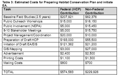
The cost of preparing the draft habitat conservation plan and to initiate a NEPA EA is estimated to be approximately: $804,509 of which $229,926 is non-federal match (in-kind donations). Table 3 is a breakdown of the costs.
The County is requesting an initial grant of $574,583 to prepare the draft habitat conservation plan and initiate a NEPA EA. The County and volunteers will provide a 29% match of $229,926 in in-kind services.
Schedule
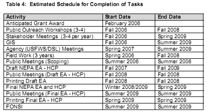
Preparation of the habitat conservation plan and EA is estimated to take approximately 3.5 years (through 2009). The first 2.5 years will be spent conducting a baseline evaluation to determine the extent of occupied and potential habitat for the six species to be covered by the habitat conservation plan, public outreach, and development of a draft plan and initiation of the NEPA EA documents. Table 4 is a schedule, by activity, for the preparation of the Habitat Conservation Plan and EA. Funding requested at this time is for the first three years.


