File:Helene and Milton 2024.jpeg
Helene_and_Milton_2024.jpeg (522 × 485 pixels, file size: 111 KB, MIME type: image/jpeg)
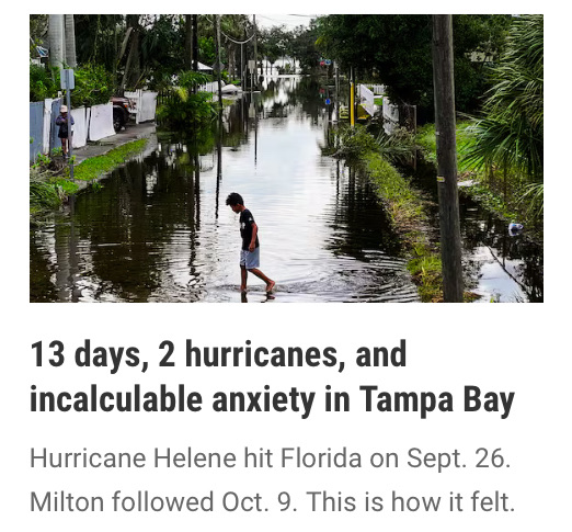
Photo via the Tampa Bay Times
Hurricanes Helene and Milton
October
Update from GreenPolicy360: The past two weeks here in Florida have seen us scramble to prepare defenses against hurricanes here at "The Frontlines of Climate Change". Two hurricanes targeted our home state, and both delivered devastation. GreenPolicy360's home base on Tampa Bay was fortunate to escape the worst, as many experienced personal disasters, homes flooded, mementoes destroyed, lives sifted and impacted now and for years.
Any accounting of losses that points at billions of dollars in expenses but misses the costs that go far beyond dollars is no 'full-cost accounting' and we have entered an era that demands clear-eyed acknowledgement of security threats and a threat-multiplier horizon. Unfortunately, even as science provides facts and data, the political voices currently holding sway in Florida are in deep denial of 'extreme weather events' and the forces driving these events.
The Governor of Florida, Ron deSantis, is on record pushing against the science of climate change and the state's government has acted to remove the use of the term. It's time for a deep rethink by the Governor, and it is overdue for the state legislature to rise in coming legislative sessions to the task at hand.
Now it is urgent to point to the near future of risks of climate-related impacts on Florida, with a multi-dimensioned approach beginning with science as a guide to smart policy. Whether related to Florida's insurance rates, or coastal development, its vulnerabilities and its blocking of effective planning and responses to climate change, a green policy approach is our common challenge. Across the political spectrum, for young and old, community by community, a turn to citizen action is a highest strategic demand *if* we are going to, in Florida and every threatened community, make a positive difference in our future.
"Earth in human hands"
- Earth is in *your* hands
🌎
October 9
The temperatures of Gulf of Mexico ocean water is trending warmer. High 80s and higher out there off the West Coast of Florida. Visitors to the coastline and barrier islands enjoy dipping into the warmness -- and so do tropical storms, cyclones, hurricanes...
GreenPolicy360: Historic Hurricanes, Weather 'Disturbances' that within Hours Intensify to Highest Categories of Destructive Storm Power
Here's a bit of Earth Science. A top of the news article via the Washington Post that puts Hurricane Milton in perspective...
...scientists say, ocean heat has increased to record levels in recent decades due to human-caused climate change. The reason is simple: The oceans, which cover more than 70 percent of Earth’s surface, absorb most of the excess heat created by burning fossil fuels. Water also can absorb large amounts of heat with relatively little temperature change, making it a very efficient place to store all the trapped heat in the atmosphere.
Using computer models, an analysis from Climate Central said the record sea surface temperatures over the past two weeks were 400 to 800 times more likely as a result of climate change.
After Hurricane Helene Comes Hurricane Milton
October 7
National Hurricane Center Advisory
BULLETIN
Hurricane Milton Intermediate Advisory Number 10A
NWS National Hurricane Center Miami FL
AL142024 1:00PM CDT Mon Oct 07 2024
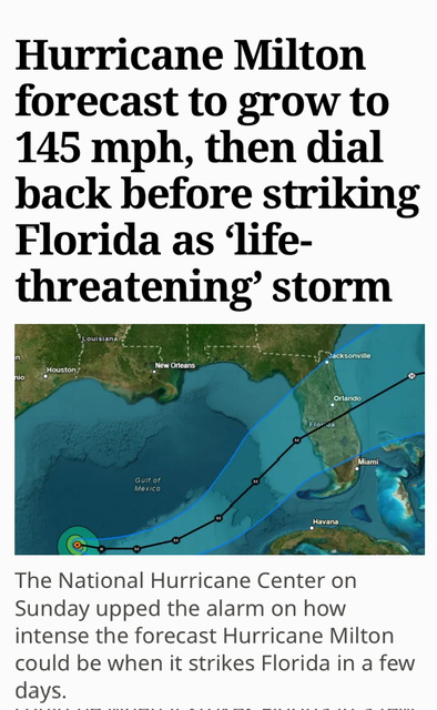
...MILTON EXPLOSIVELY INTENSIFIES WITH 175-MPH WINDS...
...RESIDENTS IN FLORIDA ARE URGED TO FOLLOW THE ADVICE OF LOCAL OFFICIALS...
SUMMARY OF 100 PM CDT...1800 UTC...INFORMATION
LOCATION...21.7N 91.3W
ABOUT 105 MI...170 KM WNW OF PROGRESO MEXICO
ABOUT 700 MI...1130 KM SW OF TAMPA FLORIDA
MAXIMUM SUSTAINED WINDS...175 MPH...280 KM/H
PRESENT MOVEMENT...E OR 100 DEGREES AT 9 MPH...15 KM/H
MINIMUM CENTRAL PRESSURE...911 MB...26.90 INCHES
October 6
- ~ ~ ~ ~ ~ ~ ~ ~ ~ ~ ~ ~ ~ ~ ~ ~ ~ ~ ~ ~ ~ ~ ~ ~ ~ ~ ~
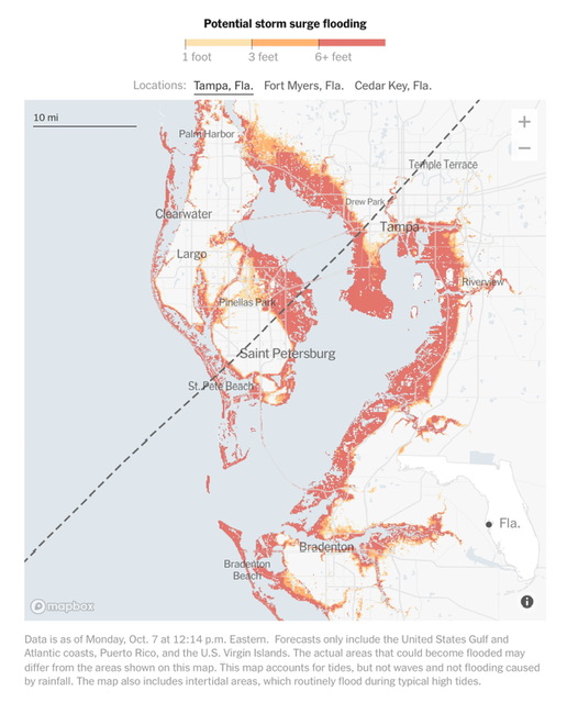
The most vulnerable metropolitan area in the U.S. to storm surge damage is Tampa/St. Petersburg...
A major hurricane) striking just north of Tampa Bay could be expected to cause $230 billion in damage – just from the storm surge. (Yale Climate Connections Study, 2015)'
”Evidence that hurricanes are getting stronger”
"Increasing destructiveness of tropical cyclones over the past 30 years"
~
File history
Click on a date/time to view the file as it appeared at that time.
| Date/Time | Thumbnail | Dimensions | User | Comment | |
|---|---|---|---|---|---|
| current | 15:00, 19 October 2024 |  | 522 × 485 (111 KB) | Siterunner (talk | contribs) |
You cannot overwrite this file.
File usage
The following 2 pages use this file:


