EarthPOV: Difference between revisions
Siterunner (talk | contribs) |
Siterunner (talk | contribs) |
||
| Line 5: | Line 5: | ||
[[File:3D Overview.jpg]] | [[File:3D Overview.jpg]] | ||
Ω | |||
Revision as of 13:21, 1 September 2014
Here's looking at us
Ω
September 1, 2014
Oldie but good one -- Here's to venturing & Labor day on the #ISS --
We are in Clearwater at 0:52 - Where are you?
File:0.50...0.52... FL flyby.jpg
Ω
With appreciation of the Overview Effect. Here's looking at us, an earth point of view with wondrous realization...
Overview, the movie Planetary #EarthPOV
Ω
With a Supermoon setting ~ August 2014
Ω
August 11, 2014
1st light! OCO-2 announces their data!
The newly launched Orbiting Carbon Observatory is now at the front of the international “Afternoon Constellation,” the “A-Train” of Earth-observing satellites in orbit. Their synchronized collection of data is a first and advances #earthmonitoring with a qualitative, quantum leap. Go we go!! Orbiting Carbon Observatory And while the A Train rolls on in the sky, maybe you'd like to listen to old but always good Duke Ellington's A Train ;-)
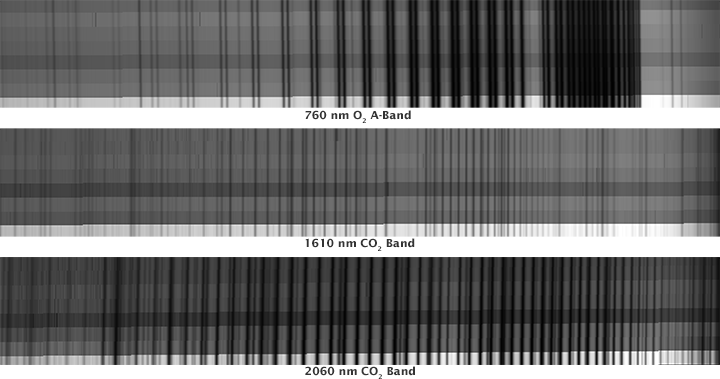
The image [spectra image below] shows some of the first data taken by OCO-2 as it flew over Papua-New Guinea forests on August 6, 2014. Each plot shows three different spectra, or wavelength, observed by the satellite’s spectrometers: 760 nanometers (atmospheric oxygen), 1610 nanometers (carbon dioxide), and 2060 nanometers (carbon dioxide).
As OCO-2 flies over Earth’s sunlit hemisphere, each spectrometer collects a frame three times per second (a total of about 9,000 frames from each orbit). Each frame is divided into eight spectra that record the amount of molecular oxygen or carbon dioxide over adjacent ground footprints, each of which is about 2.25 kilometers (1.39 miles) long and a few hundred meters wide. When displayed as an image, the spectra appear like bar codes. The dark lines indicate absorption by molecular oxygen or carbon dioxide.
“The initial data from OCO-2 appear exactly as expected [the scientists applaud here!]; the spectra lines are well resolved, sharp, and deep,” said OCO-2 chief architect and calibration lead Randy Pollock of NASA’s Jet Propulsion Laboratory.
“We still have a lot of work to do to go from having a working instrument to having a well-calibrated and scientifically useful instrument, but this was an amazingly important milestone.”
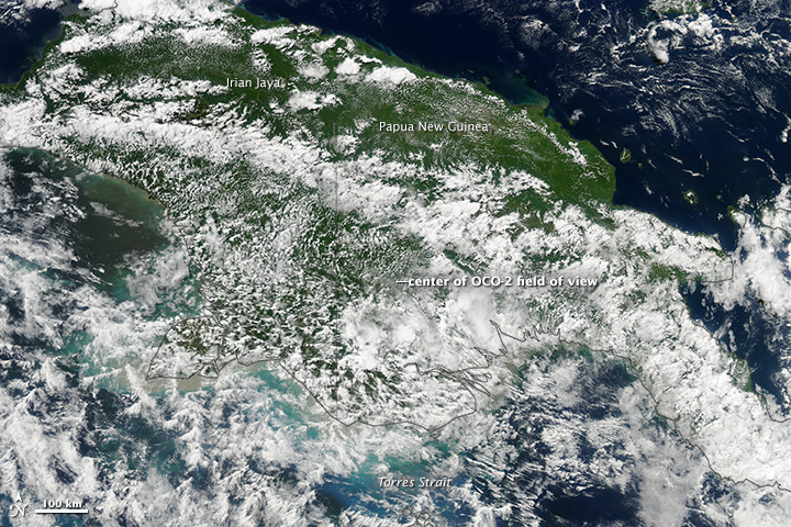
To put the spectra in context, this natural-color image shows the cloudy, forested scene below OCO-2 just minutes after it collected its data.
The color image was acquired by the Moderate Resolution Imaging Spectroradiometer (MODIS) on NASA’s Aqua satellite, which flies in the A Train orbit.
Ω
Observing Global Warming with #OCO-2 The historic launch #planetcitizen mission to study #earthsatmosphere [1] [2]
OCO-2 tweets - https://twitter.com/IamOCO2 OCO-2 announces 'We have data!'
What monitoring a potential existential crisis looks like...spectra from #OCO-2 #Earth360 [3]
Looking closer at OCO-2
Ω
'Watching the Earth Breathe from Space' [4] [5] [6] [7] [8]
"Look at how thin our atmosphere is. This is all there is between humankind and deadly space." [9]
June/July/August 2014
Astronaut Alex Gerst on the #ISS [10] [11]
Fact: We are just beginning to geo-monitor our thin atmosphere, earth and biosphere from space...
A thin atmospheric layer enabling life as we know it... [12] [13] [14] [15] [16] [17] [18] [19] [20] [21] [22]
Beginning with first 'whole earth' images of our home planet, taken in the Apollo era... [23] [24]
We are now flying eyes-in-the-sky, earth-monitoring producing first-generation data and #sustainability realizations... [25]
NASA's Earth Right Now transitioning from military to environmental security... NASA establishing itself "as a world leader in Earth science and climate studies..."
Ω


